
Storm Prediction Center Severe Thunderstorm Watch 64
2 min read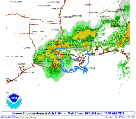

Note:
The expiration time in the watch graphic is amended if the watch is
replaced, cancelled or extended.
Note: Click for Watch Status Reports.
   SEL4

   URGENT - IMMEDIATE BROADCAST REQUESTED
   Severe Thunderstorm Watch Number 64
   NWS Storm Prediction Center Norman OK
   625 AM CDT Mon Mar 24 2025

   The NWS Storm Prediction Center has issued a

   * Severe Thunderstorm Watch for portions of
     Southern Louisiana
     Far Southeast Mississippi
     Coastal Waters

   * Effective this Monday morning from 625 AM until 1100 AM CDT.

   * Primary threats include...
     Scattered damaging winds likely with isolated significant gusts
       to 75 mph possible
     A tornado or two possible

   SUMMARY...A well-organized bowing line of storms will continue
   steadily east-northeastward this morning with wind damage as the
   primary hazard.

   The severe thunderstorm watch area is approximately along and 50
   statute miles north and south of a line from 65 miles northwest of
   Houma LA to 35 miles east southeast of Slidell LA. For a complete
   depiction of the watch see the associated watch outline update
   (WOUS64 KWNS WOU4).

   PRECAUTIONARY/PREPAREDNESS ACTIONS...

   REMEMBER...A Severe Thunderstorm Watch means conditions are
   favorable for severe thunderstorms in and close to the watch area.
   Persons in these areas should be on the lookout for threatening
   weather conditions and listen for later statements and possible
   warnings. Severe thunderstorms can and occasionally do produce
   tornadoes.

   &&

   AVIATION...A few severe thunderstorms with hail surface and aloft to
   1 inch. Extreme turbulence and surface wind gusts to 65 knots. A few
   cumulonimbi with maximum tops to 500. Mean storm motion vector
   25045.

   ...Guyer

2025-03-24 11:25:03


