
Storm Prediction Center Tornado Watch 26
2 min read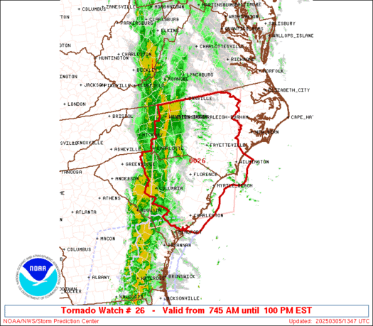
Note:
The expiration time in the watch graphic is amended if the watch is
replaced, cancelled or extended.
Note: Click for Watch Status Reports.
   SEL6

   URGENT - IMMEDIATE BROADCAST REQUESTED
   Tornado Watch Number 26
   NWS Storm Prediction Center Norman OK
   745 AM EST Wed Mar 5 2025

   The NWS Storm Prediction Center has issued a

   * Tornado Watch for portions of
     Central and Eastern North Carolina
     Central and Eastern South Carolina
     Coastal Waters

   * Effective this Wednesday morning and afternoon from 745 AM
     until 100 PM EST.

   * Primary threats include...
     A couple tornadoes possible
     Scattered damaging wind gusts to 70 mph likely

   SUMMARY...A broken squall line will continue east across the Watch
   area through the midday into the early afternoon.  Very strong wind
   fields and a destabilizing airmass will support the potential for
   embedded circulations in the squall line to pose a risk for damaging
   gusts (55-70 mph) and a threat for tornadoes.

   The tornado watch area is approximately along and 95 statute miles
   east and west of a line from 50 miles north of Raleigh NC to 10
   miles south of Charleston SC. For a complete depiction of the watch
   see the associated watch outline update (WOUS64 KWNS WOU6).

   PRECAUTIONARY/PREPAREDNESS ACTIONS...

   REMEMBER...A Tornado Watch means conditions are favorable for
   tornadoes and severe thunderstorms in and close to the watch
   area. Persons in these areas should be on the lookout for
   threatening weather conditions and listen for later statements
   and possible warnings.

   &&

   OTHER WATCH INFORMATION...CONTINUE...WW 25...

   AVIATION...Tornadoes and a few severe thunderstorms with hail
   surface and aloft to 0.5 inches. Extreme turbulence and surface wind
   gusts to 60 knots. A few cumulonimbi with maximum tops to 300. Mean
   storm motion vector 24035.

   ...Smith

2025-03-05 12:45:03
