
Storm Prediction Center Tornado Watch 18
3 min read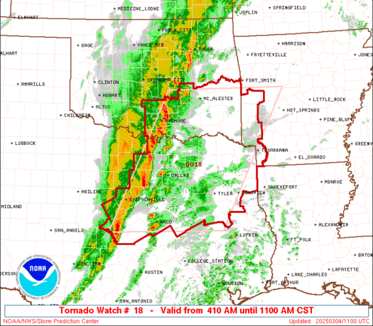

Note:
The expiration time in the watch graphic is amended if the watch is
replaced, cancelled or extended.
Note: Click for Watch Status Reports.
   SEL8

   URGENT - IMMEDIATE BROADCAST REQUESTED
   Tornado Watch Number 18
   NWS Storm Prediction Center Norman OK
   410 AM CST Tue Mar 4 2025

   The NWS Storm Prediction Center has issued a

   * Tornado Watch for portions of
     Southwest Arkansas
     Southern and Southeast Oklahoma
     Central into North and Northeast Texas

   * Effective this Tuesday morning from 410 AM until 1100 AM CST.

   * Primary threats include...
     A few tornadoes possible
     Scattered damaging winds likely with isolated significant gusts
       to 75 mph possible
     Isolated large hail events to 1.5 inches in diameter possible

   SUMMARY...A mature squall line will continue to quickly move
   eastward across the Watch area this morning.  The potential for
   severe gusts (60-75 mph) and a tornado risk will accompany the
   squall line.  A possibility also exists for a few storms to develop
   ahead of the squall line and a threat for tornadoes and large hail
   may occur with this potential activity.

   The tornado watch area is approximately along and 105 statute miles
   east and west of a line from 20 miles west northwest of Poteau OK to
   25 miles southeast of Waco TX. For a complete depiction of the watch
   see the associated watch outline update (WOUS64 KWNS WOU8).

   PRECAUTIONARY/PREPAREDNESS ACTIONS...

   REMEMBER...A Tornado Watch means conditions are favorable for
   tornadoes and severe thunderstorms in and close to the watch
   area. Persons in these areas should be on the lookout for
   threatening weather conditions and listen for later statements
   and possible warnings.

   &&

   OTHER WATCH INFORMATION...CONTINUE...WW 17...

   AVIATION...Tornadoes and a few severe thunderstorms with hail
   surface and aloft to 1.5 inches. Extreme turbulence and surface wind
   gusts to 65 knots. A few cumulonimbi with maximum tops to 450. Mean
   storm motion vector 23045.

   ...Smith

2025-03-04 10:11:02


