
Storm Prediction Center Tornado Watch 5
2 min read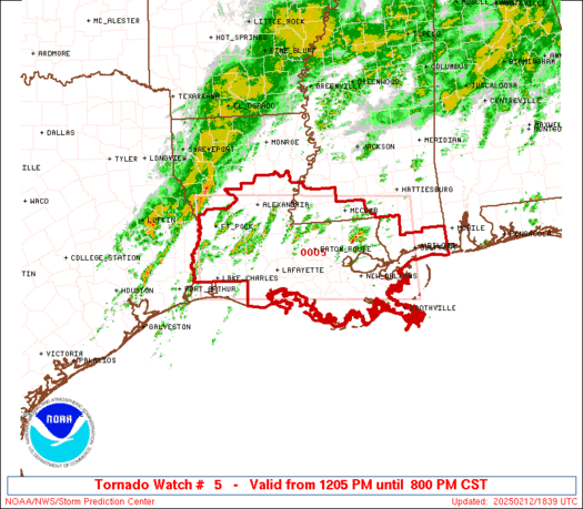

Note:
The expiration time in the watch graphic is amended if the watch is
replaced, cancelled or extended.
Note: Click for Watch Status Reports.
   SEL5

   URGENT - IMMEDIATE BROADCAST REQUESTED
   Tornado Watch Number 5
   NWS Storm Prediction Center Norman OK
   1205 PM CST Wed Feb 12 2025

   The NWS Storm Prediction Center has issued a

   * Tornado Watch for portions of
     Southern and Central Louisiana
     Southern Mississippi
     Coastal Waters

   * Effective this Wednesday afternoon and evening from 1205 PM
     until 800 PM CST.

   * Primary threats include...
     A few tornadoes possible
     Scattered damaging wind gusts to 70 mph possible
     Isolated large hail events to 1 inch in diameter possible

   SUMMARY...Severe thunderstorms are expected to develop and increase
   into mid/late afternoon within a warm and increasingly moist
   environment. Damaging winds and a few tornadoes may occur through
   early evening.

   The tornado watch area is approximately along and 65 statute miles
   north and south of a line from 35 miles southwest of Fort Polk LA to
   Gulfport MS. For a complete depiction of the watch see the
   associated watch outline update (WOUS64 KWNS WOU5).

   PRECAUTIONARY/PREPAREDNESS ACTIONS...

   REMEMBER...A Tornado Watch means conditions are favorable for
   tornadoes and severe thunderstorms in and close to the watch
   area. Persons in these areas should be on the lookout for
   threatening weather conditions and listen for later statements
   and possible warnings.

   &&

   AVIATION...Tornadoes and a few severe thunderstorms with hail
   surface and aloft to 1 inch. Extreme turbulence and surface wind
   gusts to 60 knots. A few cumulonimbi with maximum tops to 500. Mean
   storm motion vector 23030.

   ...Guyer

2025-02-12 18:05:03


