
Storm Prediction Center Severe Thunderstorm Watch 196
3 min read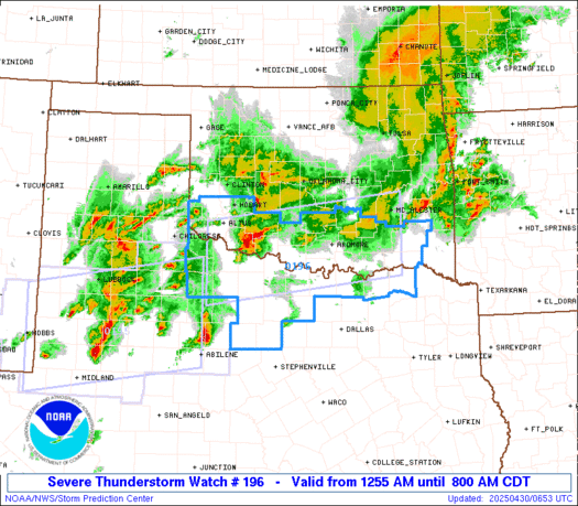

Note:
The expiration time in the watch graphic is amended if the watch is
replaced, cancelled or extended.
Note: Click for Watch Status Reports.
   SEL6

   URGENT - IMMEDIATE BROADCAST REQUESTED
   Severe Thunderstorm Watch Number 196
   NWS Storm Prediction Center Norman OK
   1255 AM CDT Wed Apr 30 2025

   The NWS Storm Prediction Center has issued a

   * Severe Thunderstorm Watch for portions of
     Southwest and South-Central Oklahoma
     Northwest and North-Central Texas

   * Effective this Wednesday morning from 1255 AM until 800 AM CDT.

   * Primary threats include...
     Scattered large hail and isolated very large hail events to 2
       inches in diameter likely
     Scattered damaging wind gusts to 70 mph likely
     A tornado or two possible

   SUMMARY...Strong to severe thunderstorms are expected to persist
   throughout the night in the vicinity of an outflow boundary that
   extends across the region. Hail will be the primary risk with this
   more cellular development. There is also some potential for the
   storms in west TX to evolve into an organized line segment that
   could progress across the region later. Damaging gusts would be the
   primary risk with this more linear activity.

   The severe thunderstorm watch area is approximately along and 50
   statute miles north and south of a line from 50 miles south
   southwest of Altus OK to 30 miles south southeast of Mcalester OK.
   For a complete depiction of the watch see the associated watch
   outline update (WOUS64 KWNS WOU6).

   PRECAUTIONARY/PREPAREDNESS ACTIONS...

   REMEMBER...A Severe Thunderstorm Watch means conditions are
   favorable for severe thunderstorms in and close to the watch area.
   Persons in these areas should be on the lookout for threatening
   weather conditions and listen for later statements and possible
   warnings. Severe thunderstorms can and occasionally do produce
   tornadoes.

   &&

   OTHER WATCH INFORMATION...CONTINUE...WW 194...WW 195...

   AVIATION...A few severe thunderstorms with hail surface and aloft to
   2 inches. Extreme turbulence and surface wind gusts to 60 knots. A
   few cumulonimbi with maximum tops to 500. Mean storm motion vector
   24035.

   ...Mosier

2025-04-30 05:55:03


