
Storm Prediction Center Mesoscale Discussion 552
1 min read|
|
| Mesoscale Discussion 552 | |
| < Previous MD | |
|
|
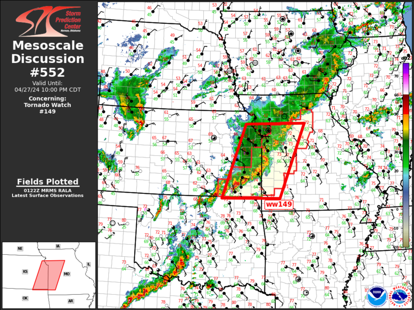
Mesoscale Discussion 0552 NWS Storm Prediction Center Norman OK 0813 PM CDT Thu Apr 24 2025 Areas affected...Southeastern Colorado into Western Kansas Concerning...Severe Thunderstorm Watch 169... Valid 250113Z - 250245Z The severe weather threat for Severe Thunderstorm Watch 169 continues. SUMMARY...The severe weather threat across WW 169 continues into the evening, with large hail and damaging winds the primary hazards. Some downstream watch extensions may be necessary as a linear convective segment matures moving into western Kansas. DISCUSSION...The severe weather threat for WW 169 continues this evening, particularly across northern portions of the watch area in southeastern Colorado, as thunderstorm clusters have begun to loosely organize into a linear convective segment. While the overall coverage of severe storms has been low thus far, SPC surface mesoanalysis data show MUCAPE increasing with eastward extent, coupled with deep-layer bulk shear of 40-45 kts. This should support continued organization of the linear convective complex as it moves into western Kansas, shifting gradually from a hail/wind threat to a primarily damaging wind threat later into the evening. ..Halbert.. 04/25/2025 ...Please see www.spc.noaa.gov for graphic product... ATTN...WFO...DDC...GLD...PUB...BOU... LAT...LON 38870450 39100437 39180382 39350345 39510309 39840281 39810216 39730181 39440154 39160138 38880137 38700140 38460154 38100177 37930204 37780235 37660270 37660310 37820363 38200410 38490434 38870450 MOST PROBABLE PEAK TORNADO INTENSITY...UP TO 95 MPH MOST PROBABLE PEAK WIND GUST...55-70 MPH MOST PROBABLE PEAK HAIL SIZE...1.50-2.50 IN |
|
|
Top/All Mesoscale Discussions/Forecast Products/Home |
|
2025-04-25 01:31:02


