
Storm Prediction Center Mesoscale Discussion 536
1 min read|
|
| Mesoscale Discussion 536 | |
| < Previous MD | |
|
|
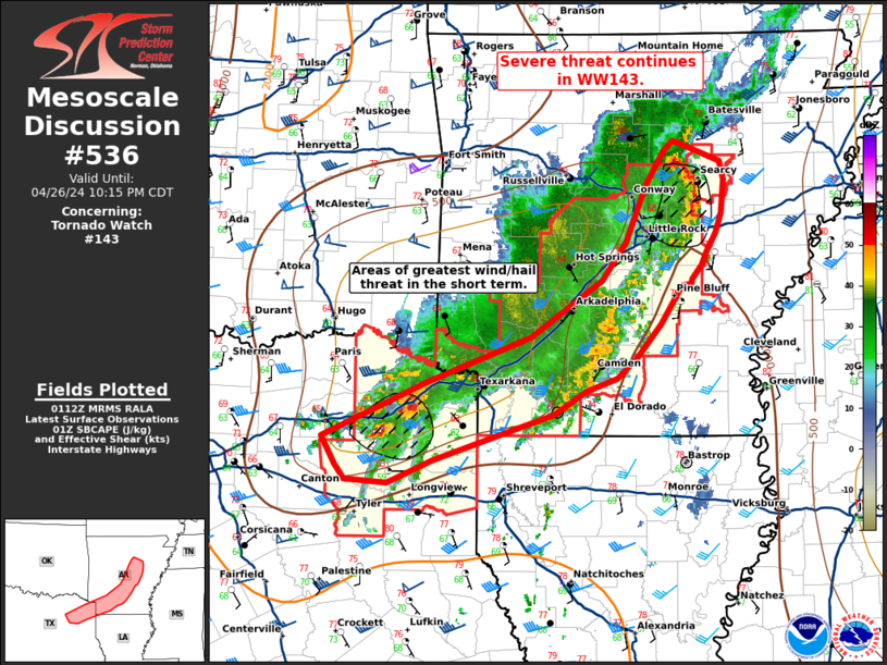
Mesoscale Discussion 0536 NWS Storm Prediction Center Norman OK 0933 PM CDT Wed Apr 23 2025 Areas affected...TX Trans-Pecos into parts of the Edwards Plateau Concerning...Severe Thunderstorm Watch 162... Valid 240233Z - 240400Z The severe weather threat for Severe Thunderstorm Watch 162 continues. SUMMARY...Strong to locally severe storms may continue into late evening. DISCUSSION...A small storm cluster is ongoing this evening to the southeast of Fort Stockton. A gradual weakening trend has been noted over the last hour, potentially due to gradually increasing MLCINH with the onset of nocturnal cooling. However, favorable boundary-layer moisture beneath steep midlevel lapse rates is supporting moderate to locally strong buoyancy (as noted on the 00Z MAF and DRT soundings), with MLCAPE in excess of 2000 J/kg. Meanwhile, deep-layer shear (aided by a subtropical jet) remains favorable for organized convection. Some potential remains for an uptick in storm intensity through late evening, aided by increasing low-level southeasterly flow (as noted in recent VWPs from KDFX). Any notable uptick could be accompanied by at least a low-probability threat for all severe hazards, though it remains uncertain if organized convection can become reestablished within an increasingly capped environment. ..Dean.. 04/24/2025 ...Please see www.spc.noaa.gov for graphic product... ATTN...WFO...EWX...SJT...MAF... LAT...LON 31070248 31110138 31010048 30140044 29580077 29510107 29520148 29620221 29770290 30180282 31070248 MOST PROBABLE PEAK TORNADO INTENSITY...85-115 MPH MOST PROBABLE PEAK WIND GUST...55-70 MPH MOST PROBABLE PEAK HAIL SIZE...1.50-2.50 IN |
|
|
Top/All Mesoscale Discussions/Forecast Products/Home |
|
2025-04-24 02:35:02


