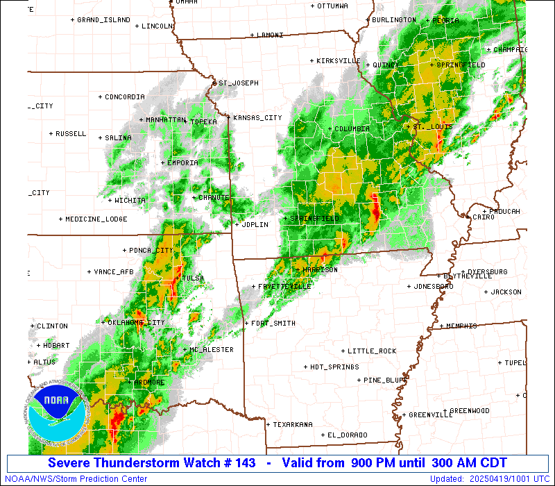
Storm Prediction Center Severe Thunderstorm Watch 143
4 min read
5 months ago
Note:
The expiration time in the watch graphic is amended if the watch is
replaced, cancelled or extended. Note: Click for Watch Status Reports.
   SEL3

   URGENT - IMMEDIATE BROADCAST REQUESTED
   Severe Thunderstorm Watch Number 143
   NWS Storm Prediction Center Norman OK
   900 PM CDT Fri Apr 18 2025

   The NWS Storm Prediction Center has issued a

   * Severe Thunderstorm Watch for portions of
     Northern Arkansas
     Southern and Eastern Missouri
     Eastern Oklahoma

   * Effective this Friday night and Saturday morning from 900 PM
     until 300 AM CDT.

   * Primary threats include...
     Scattered large hail events to 1.5 inches in diameter likely
     Isolated damaging wind gusts to 70 mph possible
     A tornado or two possible

   SUMMARY...Strong to severe thunderstorms will continue to increase
   across the region through the remainder of the evening into the
   overnight.

   The severe thunderstorm watch area is approximately along and 65
   statute miles north and south of a line from 40 miles north
   northwest of Mcalester OK to 35 miles north of Farmington MO. For a
   complete depiction of the watch see the associated watch outline
   update (WOUS64 KWNS WOU3).

   PRECAUTIONARY/PREPAREDNESS ACTIONS...

   REMEMBER...A Severe Thunderstorm Watch means conditions are
   favorable for severe thunderstorms in and close to the watch area.
   Persons in these areas should be on the lookout for threatening
   weather conditions and listen for later statements and possible
   warnings. Severe thunderstorms can and occasionally do produce
   tornadoes.

   &&

   AVIATION...A few severe thunderstorms with hail surface and aloft to
   1.5 inches. Extreme turbulence and surface wind gusts to 60 knots. A
   few cumulonimbi with maximum tops to 500. Mean storm motion vector
   23030.

   ...Guyer
Note:
The Aviation Watch (SAW) product is an approximation to the watch area.
The actual watch is depicted by the shaded areas.
   SAW3
   WW 143 SEVERE TSTM AR MO OK 190200Z - 190800Z
   AXIS..65 STATUTE MILES NORTH AND SOUTH OF LINE..
   40NNW MLC/MCALESTER OK/ - 35N FAM/FARMINGTON MO/
   ..AVIATION COORDS.. 55NM N/S /36NNW MLC - 35S STL/
   HAIL SURFACE AND ALOFT..1.5 INCHES. WIND GUSTS..60 KNOTS.
   MAX TOPS TO 500. MEAN STORM MOTION VECTOR 23030.

   LAT...LON 36369605 39229043 37349043 34479605

   THIS IS AN APPROXIMATION TO THE WATCH AREA.  FOR A
   COMPLETE DEPICTION OF THE WATCH SEE WOUS64 KWNS
   FOR WOU3.
Watch 143 Status Report Messages:
STATUS REPORT #2 ON WW 143

VALID 190335Z - 190440Z

THE SEVERE WEATHER THREAT CONTINUES ACROSS THE ENTIRE WATCH AREA.

..BENTLEY..04/19/25

ATTN...WFO...TSA...LZK...SGF...LSX...

&&

STATUS REPORT FOR WS 143

SEVERE WEATHER THREAT CONTINUES FOR THE FOLLOWING AREAS

ARC007-009-015-033-087-143-190440-

AR
.    ARKANSAS COUNTIES INCLUDED ARE

BENTON		     BOONE		 CARROLL
CRAWFORD	     MADISON		 WASHINGTON
$$


MOC009-029-039-043-055-057-059-065-067-071-073-077-085-091-093-
097-099-105-109-119-123-125-131-145-151-153-161-167-169-179-183-
186-187-189-203-209-213-215-219-221-225-229-510-190440-

MO
.    MISSOURI COUNTIES INCLUDED ARE

BARRY		     CAMDEN		 CEDAR
CHRISTIAN	     CRAWFORD		 DADE
DALLAS		     DENT		 DOUGLAS
FRANKLIN	     GASCONADE		 GREENE
HICKORY 	     HOWELL		 IRON
JASPER		     JEFFERSON		 LACLEDE
LAWRENCE	     MCDONALD		 MADISON
MARIES		     MILLER		 NEWTON
OSAGE		     OZARK		 PHELPS
POLK		     PULASKI		 REYNOLDS
ST. CHARLES	     STE. GENEVIEVE	 ST. FRANCOIS
ST. LOUIS	     SHANNON		 STONE
TANEY		     TEXAS		 WARREN
WASHINGTON	     WEBSTER		 WRIGHT


MISSOURI INDEPENDENT CITIES INCLUDED ARE

ST. LOUIS CITY
$$


OKC001-021-035-037-041-061-091-097-101-107-111-115-121-131-135-
143-145-190440-

OK
.    OKLAHOMA COUNTIES INCLUDED ARE

ADAIR		     CHEROKEE		 CRAIG
CREEK		     DELAWARE		 HASKELL
MCINTOSH	     MAYES		 MUSKOGEE
OKFUSKEE	     OKMULGEE		 OTTAWA
PITTSBURG	     ROGERS		 SEQUOYAH
TULSA		     WAGONER
$$


THE WATCH STATUS MESSAGE IS FOR GUIDANCE PURPOSES ONLY.  PLEASE
REFER TO WATCH COUNTY NOTIFICATION STATEMENTS FOR OFFICIAL
INFORMATION ON COUNTIES...INDEPENDENT CITIES AND MARINE ZONES
CLEARED FROM SEVERE THUNDERSTORM AND TORNADO WATCHES.
$$

STATUS REPORT #1 ON WW 143

VALID 190240Z - 190340Z

THE SEVERE WEATHER THREAT CONTINUES ACROSS THE ENTIRE WATCH AREA.

..BENTLEY..04/19/25

ATTN...WFO...TSA...LZK...SGF...LSX...

&&

STATUS REPORT FOR WS 143

SEVERE WEATHER THREAT CONTINUES FOR THE FOLLOWING AREAS

ARC007-009-015-033-087-143-190340-

AR
.    ARKANSAS COUNTIES INCLUDED ARE

BENTON		     BOONE		 CARROLL
CRAWFORD	     MADISON		 WASHINGTON
$$


MOC009-029-039-043-055-057-059-065-067-071-073-077-085-091-093-
097-099-105-109-119-123-125-131-145-151-153-161-167-169-179-183-
186-187-189-203-209-213-215-219-221-225-229-510-190340-

MO
.    MISSOURI COUNTIES INCLUDED ARE

BARRY		     CAMDEN		 CEDAR
CHRISTIAN	     CRAWFORD		 DADE
DALLAS		     DENT		 DOUGLAS
FRANKLIN	     GASCONADE		 GREENE
HICKORY 	     HOWELL		 IRON
JASPER		     JEFFERSON		 LACLEDE
LAWRENCE	     MCDONALD		 MADISON
MARIES		     MILLER		 NEWTON
OSAGE		     OZARK		 PHELPS
POLK		     PULASKI		 REYNOLDS
ST. CHARLES	     STE. GENEVIEVE	 ST. FRANCOIS
ST. LOUIS	     SHANNON		 STONE
TANEY		     TEXAS		 WARREN
WASHINGTON	     WEBSTER		 WRIGHT


MISSOURI INDEPENDENT CITIES INCLUDED ARE

ST. LOUIS CITY
$$


OKC001-021-035-037-041-061-091-097-101-107-111-115-121-131-135-
143-145-190340-

OK
.    OKLAHOMA COUNTIES INCLUDED ARE

ADAIR		     CHEROKEE		 CRAIG
CREEK		     DELAWARE		 HASKELL
MCINTOSH	     MAYES		 MUSKOGEE
OKFUSKEE	     OKMULGEE		 OTTAWA
PITTSBURG	     ROGERS		 SEQUOYAH
TULSA		     WAGONER
$$


THE WATCH STATUS MESSAGE IS FOR GUIDANCE PURPOSES ONLY.  PLEASE
REFER TO WATCH COUNTY NOTIFICATION STATEMENTS FOR OFFICIAL
INFORMATION ON COUNTIES...INDEPENDENT CITIES AND MARINE ZONES
CLEARED FROM SEVERE THUNDERSTORM AND TORNADO WATCHES.
$$
Probability of 1 or more strong (EF2-EF5) tornadoes
Low (10%)
Wind
Probability of 10 or more severe wind events
Mod (30%)
Probability of 1 or more wind events > 65 knots
Low (20%)
Hail
Probability of 10 or more severe hail events
High (70%)
Probability of 1 or more hailstones > 2 inches
Low (20%)
Combined Severe Hail/Wind
Probability of 6 or more combined severe hail/wind events
High (90%)
For each watch, probabilities for particular events inside the watch
(listed above in each table) are determined by the issuing forecaster.
The “Low” category contains probability values ranging from less than 2%
to 20% (EF2-EF5 tornadoes), less than 5% to 20% (all other probabilities),
“Moderate” from 30% to 60%, and “High” from 70% to greater than 95%.
High values are bolded and lighter in color to provide awareness of
an increased threat for a particular event.