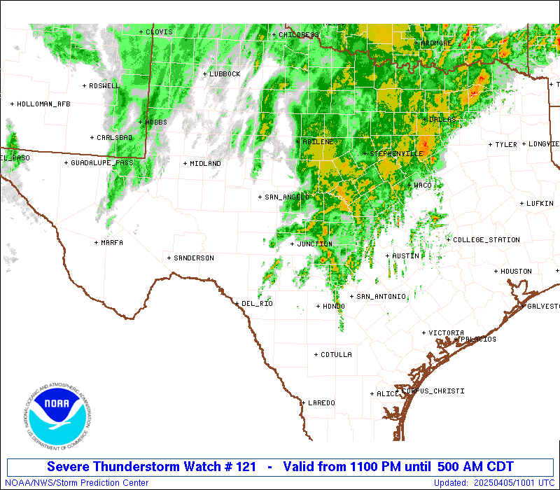
Storm Prediction Center Severe Thunderstorm Watch 121
4 min read
4 months ago
Note:
The expiration time in the watch graphic is amended if the watch is
replaced, cancelled or extended. Note: Click for Watch Status Reports.
   SEL1

   URGENT - IMMEDIATE BROADCAST REQUESTED
   Severe Thunderstorm Watch Number 121
   NWS Storm Prediction Center Norman OK
   1100 PM CDT Fri Apr 4 2025

   The NWS Storm Prediction Center has issued a

   * Severe Thunderstorm Watch for portions of
     Central Texas

   * Effective this Friday night and Saturday morning from 1100 PM
     until 500 AM CDT.

   * Primary threats include...
     Scattered large hail and isolated very large hail events to 2.5
       inches in diameter likely
     Scattered damaging wind gusts to 70 mph likely

   SUMMARY...Thunderstorms are expected to rapidly intensify across
   central Texas and affect the watch area through the early morning
   hours.  Large hail is the main concern with these storms.

   The severe thunderstorm watch area is approximately along and 80
   statute miles north and south of a line from 70 miles northwest of
   Del Rio TX to 50 miles north of Austin TX. For a complete depiction
   of the watch see the associated watch outline update (WOUS64 KWNS
   WOU1).

   PRECAUTIONARY/PREPAREDNESS ACTIONS...

   REMEMBER...A Severe Thunderstorm Watch means conditions are
   favorable for severe thunderstorms in and close to the watch area.
   Persons in these areas should be on the lookout for threatening
   weather conditions and listen for later statements and possible
   warnings. Severe thunderstorms can and occasionally do produce
   tornadoes.

   &&

   OTHER WATCH INFORMATION...CONTINUE...WW 119...WW 120...

   AVIATION...A few severe thunderstorms with hail surface and aloft to
   2.5 inches. Extreme turbulence and surface wind gusts to 60 knots. A
   few cumulonimbi with maximum tops to 500. Mean storm motion vector
   24030.

   ...Hart
Note:
The Aviation Watch (SAW) product is an approximation to the watch area.
The actual watch is depicted by the shaded areas.
   SAW1
   WW 121 SEVERE TSTM TX 050400Z - 051000Z
   AXIS..80 STATUTE MILES NORTH AND SOUTH OF LINE..
   70NW DRT/DEL RIO TX/ - 50N AUS/AUSTIN TX/
   ..AVIATION COORDS.. 70NM N/S /67NW DLF - 40NNW CWK/
   HAIL SURFACE AND ALOFT..2.5 INCHES. WIND GUSTS..60 KNOTS.
   MAX TOPS TO 500. MEAN STORM MOTION VECTOR 24030.

   LAT...LON 31240175 32189770 29879770 28930175

   THIS IS AN APPROXIMATION TO THE WATCH AREA.  FOR A
   COMPLETE DEPICTION OF THE WATCH SEE WOUS64 KWNS
   FOR WOU1.
Watch 121 Status Report Messages:
STATUS REPORT #2 ON WW 121

VALID 050535Z - 050640Z

THE SEVERE WEATHER THREAT CONTINUES ACROSS THE ENTIRE WATCH AREA.

..KERR..04/05/25

ATTN...WFO...EWX...FWD...SJT...

&&

STATUS REPORT FOR WS 121

SEVERE WEATHER THREAT CONTINUES FOR THE FOLLOWING AREAS

TXC019-027-029-031-049-053-081-083-091-093-095-099-105-137-171-
193-209-235-259-265-267-271-281-299-307-319-325-327-333-385-399-
411-413-431-435-451-453-463-465-491-050640-

TX
.    TEXAS COUNTIES INCLUDED ARE

BANDERA 	     BELL		 BEXAR
BLANCO		     BROWN		 BURNET
COKE		     COLEMAN		 COMAL
COMANCHE	     CONCHO		 CORYELL
CROCKETT	     EDWARDS		 GILLESPIE
HAMILTON	     HAYS		 IRION
KENDALL 	     KERR		 KIMBLE
KINNEY		     LAMPASAS		 LLANO
MCCULLOCH	     MASON		 MEDINA
MENARD		     MILLS		 REAL
RUNNELS 	     SAN SABA		 SCHLEICHER
STERLING	     SUTTON		 TOM GREEN
TRAVIS		     UVALDE		 VAL VERDE
WILLIAMSON
$$


THE WATCH STATUS MESSAGE IS FOR GUIDANCE PURPOSES ONLY.  PLEASE
REFER TO WATCH COUNTY NOTIFICATION STATEMENTS FOR OFFICIAL
INFORMATION ON COUNTIES...INDEPENDENT CITIES AND MARINE ZONES
CLEARED FROM SEVERE THUNDERSTORM AND TORNADO WATCHES.
$$

STATUS REPORT #1 ON WW 121

VALID 050445Z - 050540Z

THE SEVERE WEATHER THREAT CONTINUES ACROSS THE ENTIRE WATCH AREA.

..GUYER..04/05/25

ATTN...WFO...EWX...FWD...SJT...

&&

STATUS REPORT FOR WS 121

SEVERE WEATHER THREAT CONTINUES FOR THE FOLLOWING AREAS

TXC019-027-029-031-049-053-081-083-091-093-095-099-105-137-171-
193-209-235-259-265-267-271-281-299-307-319-325-327-333-385-399-
411-413-431-435-451-453-463-465-491-050540-

TX
.    TEXAS COUNTIES INCLUDED ARE

BANDERA 	     BELL		 BEXAR
BLANCO		     BROWN		 BURNET
COKE		     COLEMAN		 COMAL
COMANCHE	     CONCHO		 CORYELL
CROCKETT	     EDWARDS		 GILLESPIE
HAMILTON	     HAYS		 IRION
KENDALL 	     KERR		 KIMBLE
KINNEY		     LAMPASAS		 LLANO
MCCULLOCH	     MASON		 MEDINA
MENARD		     MILLS		 REAL
RUNNELS 	     SAN SABA		 SCHLEICHER
STERLING	     SUTTON		 TOM GREEN
TRAVIS		     UVALDE		 VAL VERDE
WILLIAMSON
$$


THE WATCH STATUS MESSAGE IS FOR GUIDANCE PURPOSES ONLY.  PLEASE
REFER TO WATCH COUNTY NOTIFICATION STATEMENTS FOR OFFICIAL
INFORMATION ON COUNTIES...INDEPENDENT CITIES AND MARINE ZONES
CLEARED FROM SEVERE THUNDERSTORM AND TORNADO WATCHES.
$$
Probability of 1 or more strong (EF2-EF5) tornadoes
Low (<2%)
Wind
Probability of 10 or more severe wind events
Mod (60%)
Probability of 1 or more wind events > 65 knots
Low (20%)
Hail
Probability of 10 or more severe hail events
High (70%)
Probability of 1 or more hailstones > 2 inches
Mod (60%)
Combined Severe Hail/Wind
Probability of 6 or more combined severe hail/wind events
High (>95%)
For each watch, probabilities for particular events inside the watch
(listed above in each table) are determined by the issuing forecaster.
The “Low” category contains probability values ranging from less than 2%
to 20% (EF2-EF5 tornadoes), less than 5% to 20% (all other probabilities),
“Moderate” from 30% to 60%, and “High” from 70% to greater than 95%.
High values are bolded and lighter in color to provide awareness of
an increased threat for a particular event.