
Storm Prediction Center Severe Thunderstorm Watch 29
3 min read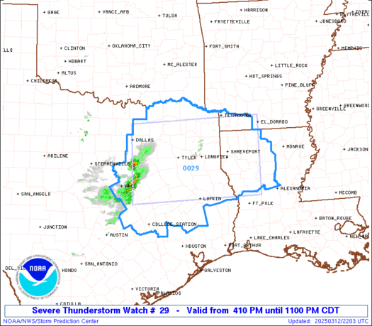
Note:
The expiration time in the watch graphic is amended if the watch is
replaced, cancelled or extended.
Note: Click for Watch Status Reports.
   SEL9

   URGENT - IMMEDIATE BROADCAST REQUESTED
   Severe Thunderstorm Watch Number 29
   NWS Storm Prediction Center Norman OK
   410 PM CDT Wed Mar 12 2025

   The NWS Storm Prediction Center has issued a

   * Severe Thunderstorm Watch for portions of
     Southwest Arkansas
     Northwest Louisiana
     North-central and Northeast Texas

   * Effective this Wednesday afternoon and evening from 410 PM
     until 1100 PM CDT.

   * Primary threats include...
     Scattered large hail likely with isolated very large hail events
       to 2.5 inches in diameter possible
     Scattered damaging wind gusts to 70 mph possible
     A tornado or two possible

   SUMMARY...Thunderstorms will continue to increase in coverage and
   intensity this afternoon and early evening. Supercells should pose a
   threat for large hail around 1.5-2.5 inches in diameter. A small
   cluster may eventually develop and pose a threat for severe/damaging
   winds of 60-70 mph through this evening.

   The severe thunderstorm watch area is approximately along and 75
   statute miles north and south of a line from 30 miles west northwest
   of Corsicana TX to 45 miles north northeast of Natchitoches LA. For
   a complete depiction of the watch see the associated watch outline
   update (WOUS64 KWNS WOU9).

   PRECAUTIONARY/PREPAREDNESS ACTIONS...

   REMEMBER...A Severe Thunderstorm Watch means conditions are
   favorable for severe thunderstorms in and close to the watch area.
   Persons in these areas should be on the lookout for threatening
   weather conditions and listen for later statements and possible
   warnings. Severe thunderstorms can and occasionally do produce
   tornadoes.

   &&

   AVIATION...A few severe thunderstorms with hail surface and aloft to
   2.5 inches. Extreme turbulence and surface wind gusts to 60 knots. A
   few cumulonimbi with maximum tops to 500. Mean storm motion vector
   26040.

   ...Gleason

2025-03-12 21:10:02


