Winter storm threatens over 60 million across 25 states with heavy snows, crippling ice
4 min read
Winter weather alerts cover over 60 million as the first major winter storm of the year sweeps across the Plains and eventually into the mid-Atlantic this weekend.
The first significant winter storm of the year is endangering a 2,100-mile swath of the country from the Northwest and Plains through the mid-Atlantic and East Coast, bringing a multitude of life-threatening hazards across major metropolitan areas, including heavy snow amid potentially blizzard-like conditions, and crippling ice accretions that could lead to extended power outages.
WINTER STORM LIVE TRACKER: SNOWFALL MAPS, CURRENT ALERTS, POWER OUTAGE FORECASTS
The storm is working its way through the Northern Rockies and Central Plains Saturday, hours after slamming the West Coast and even spawning the first tornado of the year in California.

(FOX Weather)
More than 6million residents were placed under winter weather alerts, including Winter Storm Warnings and Ice Storm Warnings, with major impacts expected between Interstates 50 and 70.
NOAA forecasters and the FOX Weather Center said travel will likely be impossible for some communities, as more than a foot of snow will bury some roadways despite efforts to pretreat pavement before the wintry weather.

(FOX Weather)
South of the heavy band of snow, ice is expected to be problematic and could accumulate to nearly an inch from southern Missouri through Kentucky and into West Virginia. The heavy glaze will likely lead to power outages, and due to the nature of the terrain, outages could last for an extended period.
Arctic air following the wintry weather will keep a large part of the northern tier of the country below freezing for several days, causing additional hardships for those unprepared for the winter wallop.
Greatest Snowfall Event of the Season
Snowfall totals are expected to approach a foot for communities in Kansas, Missouri, Illinois, Ohio and parts of West Virginia—making this winter blast the most significant event of the season, and for some areas, perhaps the largest snowfall in over a decade, according to NOAA’s Weather Prediction Center.

(FOX Weather)
Isolated higher amounts are expected in the Appalachians and along the Great Lakes, where the terrain’s influence will be in full effect.
Many towns and cities in the path of the storm system have issued snow emergencies, as crews treat major roadways and prepare for round-the-clock snow removal efforts.
“This is the big one,” Chief Safety and Operations Officer Becky Allmeroth, with the Missouri Department of Transportation, told FOX Weather on Friday. “We are messaging out ahead of time, letting motorists know that our travel is going to be just about impossible on some of our major interstates: Interstate 70, because of the volume of snow, and Interstate 44 — that’s really the prime bull’s-eye right now for some of those heavier amounts of ice.”
Heavy snows of 5-8 inches are expected across the metro areas of Kansas City, St. Louis and Louisville, with even higher amounts possible around Indianapolis. The snowfall is even expected to reach Philadelphia and Washington, D.C., where 3-6 inches are possible through Monday evening, with higher isolated amounts.
HOW MUCH ICE IS NEEDED TO KNOCK OUT POWER, DAMAGE TREES?
Significant Amounts of Ice Could Knock Out Power
South of the heavy snowfall, an ice storm looks likely, with hours of freezing rain expected, the FOX Forecast Center said.

(FOX Weather)
Ice totals of at least half an inch could accumulate in parts of southern Missouri, southern Illinois, and into the Appalachians, leading to widespread tree damage and long-lasting power outages.

(FOX Weather)
“Travel is strongly discouraged. If you must travel, keep an extra flashlight, food, and water in your vehicle in case of an emergency. Prepare for possible power outages,” an NWS meteorologist warned residents in the zone with the highest possibility of ice.
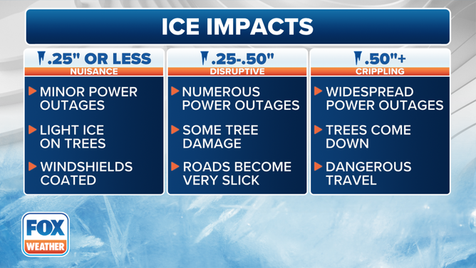
The impacts of ice accretion depend largely on the amount of ice that piles upon surfaces. When ice totals are under 0.25 inches, the effects are typically limited, causing roadways to become slick and treacherous. owever, when ice totals start to exceed 0.25 inches, the weather event becomes more serious, with power outages and weak tree branches that start to fall.

Impacts from various thicknesses of ice accretion.
(FOX Weather)
Unlike previous winter weather events this season, there doesn’t appear to be much warm air on the horizon, which means much of the snowfall will stay on the ground throughout a significant portion of the month.

(FOX Weather)
“Beyond this, we do have another round of some cold air that’s going to move in and then the coldest air following that, too. So, we have a couple of rounds here that we have to get through,” said FOX Weather meteorologist Steve Bender.
Severe Thunderstorm Risk Across the South
On the warm side of the storm system, thunderstorms are expected to develop on Sunday and Monday along the Gulf Coast.
Some of these storms are expected to meet severe criteria, with gusty winds and the potential for tornadoes.
The NOAA Storm Prediction Center has issued a slight risk for severe storms from East Texas to western Alabama, rating it a 2 out of 5 on the agency’s severe threat scale.

(FOX Weather)
These thunderstorms are expected to impact regions recently affected by a tornado outbreak in late December.
Severe thunderstorms across the South are not unusual during the winter months, as the region is in its tornado season.
Areas of the South that were recently ravaged by a deadly tornado outbreak are again finding themselves under the threat of severe weather this weekend as cleanup efforts continue.
https://images.foxweather.com/static.foxweather.com/www.foxweather.com/content/uploads/2025/01/1024/512/gettyimages-2191733985.jpg?ve=1&tl=1
2025-01-04 11:49:01


