Storm Prediction Center Mesoscale Discussion 2269
1 min read
|
|
 |
| Mesoscale Discussion 2269 | |
| < Previous MD | |

|
|
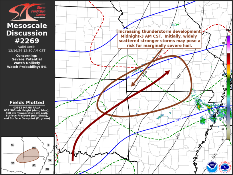
Mesoscale Discussion 2269 NWS Storm Prediction Center Norman OK 1001 PM CST Sun Dec 15 2024 Areas affected...parts of northeastern Oklahoma...northwestern Arkansas...southern Missouri Concerning...Severe potential...Watch unlikely Valid 160401Z - 160630Z Probability of Watch Issuance...5 percent SUMMARY...A substantive increase in thunderstorm development appears likely across the Ozarks Plateau vicinity into adjacent lower Ohio Valley during the Midnight-3 AM CST time frame. Initially this may include widely scattered strong storms posing a risk for marginally severe hail, particularly across parts of northeastern Oklahoma into southwestern Missouri and adjacent northwestern Arkansas. DISCUSSION...Seasonably moist low-level return flow is in the process of veering from a southwesterly to more of a westerly component in the 925-850 mb layer across eastern Oklahoma through southern Missouri. However, as moisture quality continues to increase during the next few hours, this is still forecast to lead to substantive destabilization, as mid-level heights gradually begin to fall across the southern Great Plains through Ozark Plateau vicinity. Large-scale ascent and cooling aloft appear likely to weaken inhibition sufficiently to support increasing thunderstorm development in a corridor as far east as southern Illinois and adjacent portions of the lower Ohio Valley by 08-09Z. Based on forecast soundings, destabilization across much of this swath will remain rooted above a generally cool and stable boundary layer. However, modestly steep mid-level lapse rates might contribute to sufficient conditional and convective instability to support small to marginally severe hail in widely scattered stronger initial cells, before convection becomes more widespread. Storms capable of producing severe hail may be most concentrated (in a relative sense) across northeastern Oklahoma into southwestern Missouri and adjacent northwestern Arkansas, where surface dew points are increasing to around 60F. Although destabilization may become rooted close to the surface across this area (in close proximity to the surface troughing), guidance suggests that this may coincide with low-level hodographs shrinking and trending more linear. ..Kerr/Smith.. 12/16/2024 ...Please see www.spc.noaa.gov for graphic product... ATTN...WFO...LZK...SGF...TSA... LAT...LON 36909531 37979203 36299139 35469436 35769607 36909531 |
|
|
Top/All Mesoscale Discussions/Forecast Products/Home |
|
2024-12-16 04:02:06


