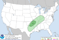
Storm Prediction Center Dec 15, 2024 1630 UTC Day 1 Convective Outlook
2 min read
   SPC AC 151630

   Day 1 Convective Outlook
   NWS Storm Prediction Center Norman OK
   1030 AM CST Sun Dec 15 2024

   Valid 151630Z - 161200Z

   ...THERE IS A MARGINAL RISK OF SEVERE THUNDERSTORMS FROM PARTS OF
   NORTH TEXAS TO THE OZARKS...

   ...SUMMARY...
   Isolated severe hail, strong/gusty winds, and perhaps a tornado may
   occur tonight through early Monday morning from parts of north Texas
   to the Ozarks.

   ...Synopsis...
   Gradual amplification and consolidation of upper troughing will
   occur through the period across parts of the northern Plains and
   Upper Midwest. The southern fringe of this upper trough will begin
   to influence and overspread portions of the central/southern Plains
   late this evening and overnight. The primary surface low will
   develop towards the international border region of northern
   MN/southern Canada, while partially modified Gulf moisture continues
   to gradually stream northward over portions of the southern Plains
   into the Ozarks ahead of a cold front.

   ...Eastern Oklahoma into Western Arkansas and Southwest Missouri...
   Convective initiation will likely be delayed until 03Z or later this
   evening across eastern OK/western AR vicinity, as low-level
   warm/moist advection aids in the northward transport of a moist
   low-level airmass. Once convection develops as glancing ascent from
   the approaching upper trough overspreads the warm sector, convective
   mode may quickly become messy, as generally southwesterly
   low/mid-level flow encourages updraft interactions and mergers. Even
   so, around 1000-2000 J/kg of MUCAPE, aided by modestly steepened
   mid-level lapse rates, should support robust updrafts. Coupled with
   sufficient (around 30-40 kt) deep-layer shear, some of this initial
   development could produce marginally severe hail on an isolated
   basis. Based on latest guidance trends showing convective initiation
   farther north across parts of northern OK into southwest MO, the
   Marginal Risk has been expanded northward to account for this
   initial hail threat.

   Poor/neutral low-level lapse rates and a generally saturated
   boundary-layer shown in various NAM/RAP forecast soundings limit
   confidence to some extent in the potential for truly surface-based
   thunderstorms tonight across the warm sector. Still, the presence of
   a 35-45 kt southwesterly low-level jet, with associated 0-1 km SRH
   sufficient for low-level updraft rotation, suggests a non-zero
   threat for a tornado along with some potential for occasional
   strong/gusty winds as convection spreads eastward across eastern OK
   into western AR and the Ozarks through early Monday morning. The
   potential for sustained supercells appears limited by a weakness in
   the flow/hodograph forecast around 700 mb, with the southward-moving
   cold front also encouraging a more linear/cluster mode with time.
   Overall, the severe threat with any convection that develops should
   remain rather isolated, but within a conditionally somewhat
   favorable environment.

   ..Gleason/Squitieri.. 12/15/2024

   CLICK TO GET WUUS01 PTSDY1 PRODUCT

   NOTE: THE NEXT DAY 1 OUTLOOK IS SCHEDULED BY 2000Z
http://www.spc.noaa.gov/products/outlook/day1otlk_sm.gif
2024-12-15 16:34:30


