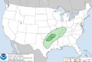
Storm Prediction Center Dec 15, 2024 1300 UTC Day 1 Convective Outlook
3 min read
   SPC AC 151224

   Day 1 Convective Outlook
   NWS Storm Prediction Center Norman OK
   0624 AM CST Sun Dec 15 2024

   Valid 151300Z - 161200Z

   ...THERE IS A MARGINAL RISK OF SEVERE THUNDERSTORMS FROM PORTIONS OF
   NORTH TEXAS TO THE OZARKS...

   ...SUMMARY...
   Isolated hail near severe limits is possible tonight from portions
   of north Texas to the Ozarks.

   ...Synopsis...
   In mid/upper levels, a low-amplitude longwave pattern will remain in
   place over the CONUS, with progressive shortwave to synoptic troughs
   traversing the prevailing westerlies.  The leading trough --
   currently anchored by a closed low near the northern IL/IN border --
   should devolve to an open wave and move to the northern Mid-Atlantic
   region by 12Z tomorrow.  Meanwhile, a series of shortwaves and
   vorticity lobes -- occupying broadly cyclonic flow over much of the
   western CONUS -- will consolidate/phase somewhat through the period
   while shifting eastward.  By 00Z, a loosely organized synoptic
   trough will extend from the Dakotas across the central High Plains
   to AZ.  Overnight, a closed 500-mb low should develop over southern
   MB, with the trough extending across central NE/KS to southern NM
   and northwestern MX by 12Z.

   At the surface, 11Z analysis showed a decaying cold to stationary
   front from eastern IL across southern AR, north-central and west-
   central TX.  This boundary will move slowly northward through the
   day and continue to weaken.  Meanwhile, cold frontogenesis is
   forecast today ahead of the mid/upper trough, and over parts of the
   central/northern Plains.  This Plains front should reach western
   parts of MN/IA, northeastern to south-central KS, and the TX
   Panhandle by 00Z.  By 12Z, the cold front should reach central/
   southern IL, the Ozarks, eastern/southern OK, and the TX South
   Plains region.

   ...North TX to the Lower OH Valley...
   Episodic, isolated to scattered thunderstorms are expected
   throughout the period, embedded in a plume of low-level warm/moist
   advection and moisture transport extending from central/east TX to
   the lower Ohio Valley.  Through the day, this activity will occur in
   weak midlevel lapse rates and modest deep shear, with most or all of
   it elevated over a relatively stable, near-surface layer, and
   accordingly minimal severe potential.  Meanwhile, surface dewpoints
   in the 60s F will spread northward into and across much of the
   outlook area, as the older boundary becomes diffuse ahead of the
   Plains cold front.

   Concurrent with height falls aloft and increasing deep shear, the
   warm conveyor and accompanying isentropic ascent to LFC should
   intensify this evening amid mass response to the consolidation/
   approach of the mid/upper trough, and related 45-55-kt LLJ.
   Greatest thunderstorm coverage in the plume is expected after about
   03Z from near the Red River Valley to the Ozarks, spreading into the
   lower Ohio Valley from around 09Z onward.  During phases when
   convection is still relatively discrete, and around the southern
   part of denser/later convective coverage, the most vigorous cells
   may produce severe hail.  Forecast soundings show a nearly
   saturated, near-neutral stability profile in the boundary layer over
   north TX to eastern OK, and perhaps into some of northwestern AR,
   depending on outflow timing/intensity.  This renders profiles that
   may be effectively surface-based, with MLCAPE in the 1000-1500 J/kg
   rage and slightly greater MUCAPE, but still often containing weak,
   near-surface static stability.  At this time, severe-gust/tornado
   potential appears too conditional and low to draw even marginal
   categorical probabilities for those hazards, and the previous
   outlook area still appears to capture the consensus of most
   probable, favorably positioned convection in the plume as well.

   ..Edwards/Goss.. 12/15/2024

   CLICK TO GET WUUS01 PTSDY1 PRODUCT

   NOTE: THE NEXT DAY 1 OUTLOOK IS SCHEDULED BY 1630Z
http://www.spc.noaa.gov/products/outlook/day1otlk_sm.gif
2024-12-15 12:28:27


