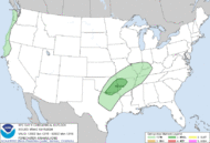
Storm Prediction Center Dec 15, 2024 0600 UTC Day 1 Convective Outlook
2 min read
   SPC AC 150544

   Day 1 Convective Outlook
   NWS Storm Prediction Center Norman OK
   1144 PM CST Sat Dec 14 2024

   Valid 151200Z - 161200Z

   ...THERE IS A MARGINAL RISK OF SEVERE THUNDERSTORMS IN FAR NORTH TX
   TO NORTHWEST AR...

   ...SUMMARY...
   A low-end severe threat, primarily in the form of marginal hail, is
   possible tonight across a portion of the Red River Valley into the
   southern Ozark Plateau.

   ...Synopsis...
   A shortwave trough will progress from the northern Great Basin into
   the Upper Midwest by tonight, with low-amplitude impulses moving
   east across the Southwest. Primary surface cyclone will deepen as it
   tracks from the Black Hills to the Lake of the Woods vicinity. An
   occluded/cold front will arc south into the Ozarks by tonight, with
   trailing portion extending southwestward in OK/TX.

   ...North TX to the Lower OH Valley...
   A broad, low-level warm/moist conveyor will become established from
   the Lower Rio Grande Valley northeastward into the Lower OH Valley
   through tonight. Low-amplitude shortwave ridging should preclude
   appreciable thunderstorm development until late evening. A swath of
   elevated storms is expected to blossom into the overnight, from
   parts of eastern OK into the Lower OH Valley as weak mid-level
   height falls overspread the gradually moistening corridor. The
   southwest extent of this regime into far north TX should contain
   surface-based parcels, although low-level lapse rates may be poor.

   Nearly unidirectional southwesterly wind profiles are progged across
   much of the warm conveyor, ahead of the similarly oriented cold
   front. M-shaped type hodographs are anticipated from southeast OK
   southwestward, with weakness in the flow around 700 mb, where MUCAPE
   appears largest from 1000-2000 J/kg. Non-FV3 members of the 00Z HREF
   and available NSSL-MPAS runs indicate minimal 2-5 km UH signal.
   Given these factors, storm mode will probably become messy early in
   the convective development life cycle. Still, conditional potential
   exists, amid an adequate combo of effective bulk shear and MUCAPE,
   for a few deeper updrafts to acquire transient rotation, with an
   associated marginally severe hail threat. Where exactly that
   transitions to purely small hail magnitudes is uncertain with
   northeast extent, as mid-level lapse rates should be more muted and
   buoyancy will be less.

   ..Grams/Lyons.. 12/15/2024

   CLICK TO GET WUUS01 PTSDY1 PRODUCT

   NOTE: THE NEXT DAY 1 OUTLOOK IS SCHEDULED BY 1300Z
http://www.spc.noaa.gov/products/outlook/day1otlk_sm.gif
2024-12-15 05:48:22


