Weak La Nina still expected this winter, last into spring after last year’s El Nino winter
3 min read
For months, the world has heard about the possibility of entering a La Niña phase, with some climate models even predicting it would occur during the previous spring. Despite these outlooks, water temperatures in parts of the Pacific have not reached the threshold required for La Niña, even though atmospheric conditions are showing characteristics typical of the pattern.
So, what’s going on? Why are parts of the world experiencing La Niña-related events without an official La Niña in place? The answer appears to be complicated and may possibly influenced by climate change.
La Niña is considered the cool phase of the El Niño-Southern Oscillation (ENSO) and is characterized by lower-than-average sea-surface temperatures, with anomalies of at least -0.5 degrees Celsius over parts of the central and eastern Pacific.

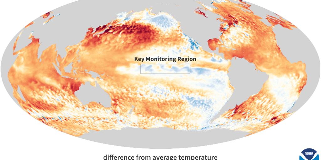
Global sea surface temperatures
(NOAA)
Officially, the world last experienced a La Niña event in the spring of 2023 and has been in an El Niño or neutral status ever since.
While the world may not officially be in a La Niña event, signs of its influence are still evident, including reduced rainfall over the Pacific, stronger-than-average trade winds and a more active hurricane season in the Atlantic.
It remains unclear whether these events are being completely driven by the ENSO or simply a warming climate, with increased water vapor levels.
“The jury is still out on what sort of changes to ENSO could occur in a warming world. There is evidence for all sorts of outcomes, whether it is more El Niños, stronger overall events, or even a decrease in the number of El Niños or La Niñas. This uncertainty is because ENSO is a complicated give-and-take between the atmosphere and ocean with a lot of different tuning knobs that each get adjusted by climate change,” Tom Di Liberto, a NOAA meteorologist and climate guru, wrote in a previous ENSO blog.
LITTLE-KNOWN WEATHER PATTERN WHEN EL NINO AND LA NINA ARE NO LONGER IN CONTROL
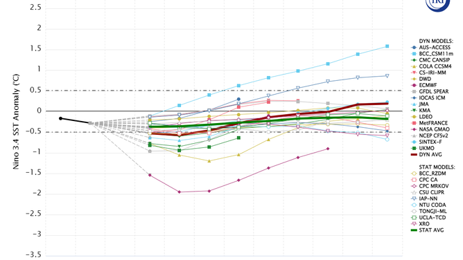
So, while the agency does expect the world to enter a weak La Niña in early 2025, the weather patterns are expected to change as the signal for the event is not strong.
In fact, the agency believes the ENSO will find itself back in neutral territory by the spring and summer of 2025 and continue in neutral status through much of the year.

ENSO Model Prediction
(The International Research Institute for Climate and Society, Columbia University Climate School / FOX Weather)
The neutral state of the ENSO occurs when water temperature anomalies in the eastern and central Pacific are between 0.5 degrees Celsius and -0.5 degrees Celsius.
Typically, there are fewer kinks in the jet stream, meaning more regional patterns dominate local weather conditions.
ENSO-neutral conditions are not known to produce historic winter seasons or busy spring severe weather outbreaks.
Every neutral summer in the past two decades has been accompanied by above-average temperatures, but again, it is unclear whether this is directly triggered by the ENSO or the continuation of the changing climate.
WHAT ARE EL NINO AND LA NINA CLIMATE PATTERNS?
“This is very much a developing story – you’re reading about scientific development and discovery in real time. Our official ENSO metrics may not describe ENSO quite as well in the context of the much-above-average global ocean temperatures we’ve seen over the past year, but we don’t know yet if the relative Niño-3.4 Index is going to consistently describe ENSO better into the future. We need more research to better understand what is happening,” NOAA researchers stated during their recent update.
https://images.foxweather.com/static.foxweather.com/www.foxweather.com/content/uploads/2024/12/1024/512/enso-blog-global-sea-surface-temperature-anomaly-november-2024.png?ve=1&tl=1
2024-12-13 00:08:23


