
VIDEO: Record rainfall engulfs Kansas town, leading to extensive flooding
3 min read

Newly released drone footage lays bare the devastating extent of flash flooding that swallowed homes and roads across south-central Kansas. Some of the heaviest rain swamped the suburb of Valley Center, located about 10 miles north of downtown Wichita.
VALLEY CENTER, Kan. – Newly released drone footage lays bare the devastating extent of flash flooding that swallowed homes and roads across south-central Kansas Tuesday.
Some of the heaviest rain swamped the suburb of Valley Center, located about 10 miles north of downtown Wichita.
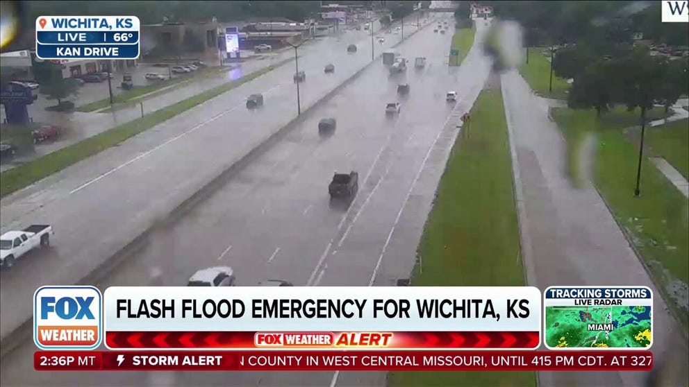
FLASH FLOOD EMERGENCY STRIKES KANSAS WITH WATER RESCUES AROUND WICHITA
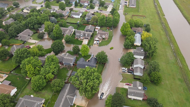
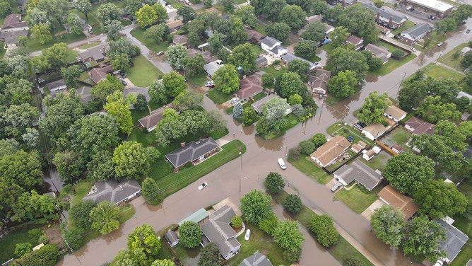
Drone footage reveals the devastating extent of flash flooding that swallowed homes and roads in Valley Center, Kansas, on Tuesday.
(Tyler Gentry – L2 Realty Inc.)
The relentless two-day downpour, delivering up to 7.29 inches of rain, submerged the town, leaving homes and cars stranded. Residents are calling it the worst flooding they’ve ever witnessed in the area. Official measurements show that 2.47 inches of rain fell Tuesday alone at Wichita’s Dwight D. Eisenhower National Airport, making it the fifth-wettest June day in the past 25 years.
-

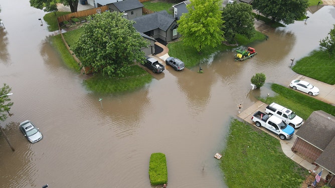
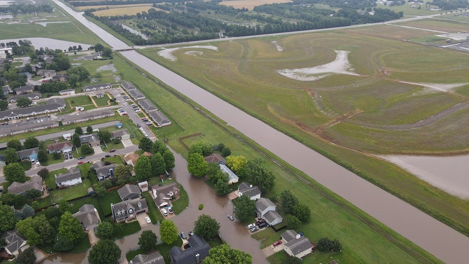
Drone footage reveals the devastating extent of flash flooding that swallowed homes and roads in Valley Center, Kansas, on Tuesday.
(Tyler Gentry – L2 Realty Inc.) -
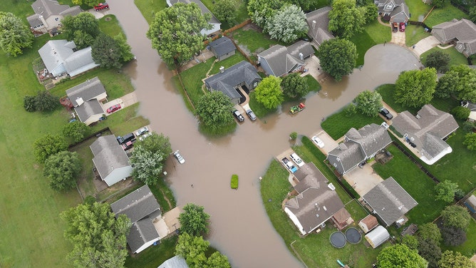
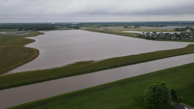
Drone footage reveals the devastating extent of flash flooding that swallowed homes and roads in Valley Center, Kansas, on Tuesday.
(Tyler Gentry – L2 Realty Inc.) -
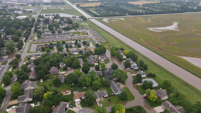
Drone footage reveals the devastating extent of flash flooding that swallowed homes and roads in Valley Center, Kansas, on Tuesday.
(Tyler Gentry – L2 Realty Inc.) -
Drone footage reveals the devastating extent of flash flooding that swallowed homes and roads in Valley Center, Kansas, on Tuesday.
(Tyler Gentry – L2 Realty Inc.) -
Drone footage reveals the devastating extent of flash flooding that swallowed homes and roads in Valley Center, Kansas, on Tuesday.
(Tyler Gentry – L2 Realty Inc.) -
Drone footage reveals the devastating extent of flash flooding that swallowed homes and roads in Valley Center, Kansas, on Tuesday.
(Tyler Gentry – L2 Realty Inc.) -
Drone footage reveals the devastating extent of flash flooding that swallowed homes and roads in Valley Center, Kansas, on Tuesday.
(Tyler Gentry – L2 Realty Inc.)

The heaviest of the rainfall occurred east of Interstate 135, where multiple water rescues were reported throughout the afternoon. Governor Laura Kelly issued a disaster emergency proclamation due to the heavy rainfall.
“We have had quite a number of submerging calls since the rainfall really started building up on us here in the city of Wichita,” Wichita Fire Rescue Battalion Chief Jose Ocadiz said.
Significant flooding was also reported in nearby El Dorado, where vehicles stood no chance on some roadways.
The Kansas Division of Emergency Management also activated the State Emergency Operations Center in Topeka to monitor the severe weather.
Thunderstorms dropped a quick half foot of rain in south-central Kansas on Tuesday.
After two Flash Flood Emergencies in Kansas on Tuesday, the flood threat remains for the rest of the week, the FOX Forecast Center said.
Very moist air from the Gulf will surge northward ahead of a cold front, combining with warm, unstable conditions to create a favorable setup for heavy rain. Rain rates in any of these storms could easily eclipse over an inch an hour at times.
Even though the storms are expected to move at a decent pace, the setup may allow some areas to see repeated rounds of heavy rain. This “training” effect, where storms form repeatedly over the same spots, could lead to totals over 3 inches, and possibly as high as 5 inches by the time it is all over.
The greatest risk for flash flooding appears to stretch from central Texas through eastern Oklahoma, and it will slowly shift east each day.
A Level 2 out of 4 flash flood risk exists for the central Plains – including Oklahoma – from Thursday through Sunday morning.
[og_img
2025-06-04 17:02:05