
Canada wildfires shroud eastern US in orange, hazy skies
3 min read

Smoke from numerous out-of-control wildfires in Canada will drift south this weekend prompting air quality alerts in Wisconsin.
ATLANTA – A series of wildfires burning across central Canada sent smoke billowing into the U.S. on Saturday, with few signs that the blazes will subside anytime soon.
The largest fires are burning in Manitoba, but due to prevailing wind patterns, plumes of smoke drifted southward, reaching as far as the Gulf Coast.
Satellites captured stunning imagery as smoke appeared to embed itself around a storm system moving through the East.
According to air quality readings across the Lower 48, the smoke was most hazardous across the Plains and the Upper Midwest, with moderate levels reaching as far south as Georgia and the Carolinas.
Communities south of the U.S.-Canada border reported Air Quality Index (AQI) readings between 200 and 400 – levels which are considered to be unhealthy to even hazardous.
A value between 0 and 50 on the AQI scale is considered “good,” while anything over 301 reaches dangerous levels.
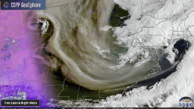
Satellite animation of smoke across eastern U.S.
(NOAA)
WHAT DOES CODE RED, CODE PURPLE AIR QUALITY MEAN?
Air quality alerts were issued for millions across the Upper Midwest, with authorities warning of additional waves of smoke for the foreseeable future.
The Minnesota Pollution Control Agency advised individuals with lung disease, asthma, heart conditions and other health concerns to limit their time outdoors.
Officials also urged residents to ensure windows and doors are properly sealed to prevent smoke from infiltrating homes.
Despite the high AQI readings and satellite imagery, most of the smoke remained elevated in the atmosphere, limiting ground-level impacts, at least for now.
Across much of the country, the smoke primarily contributed to orange-tinted skies and reduced visibility for pilots.
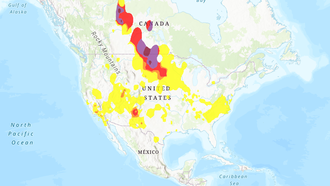
Saturday AQI map
(FOX Weather)
The scenes were a stark contrast to 2023, when smoke from Canadian wildfires settled over major cities along the Eastern Seaboard, pushing AQI readings into dangerous territory.
That year, fires burned a record 45 million acres – a stark contrast to the less than 2 million acres consumed so far in 2025.
A contingent of more than 150 U.S. firefighters has begun arriving in Canada, with additional resources expected to be deployed in the coming weeks.
“We are here to help our neighbors during their time of need, and our Forest Service Wildland Firefighters are the best in the business. I am thankful for the men and women who are bravely stepping up to serve. We pray for their success as they fight fires and save lives,” U.S. Secretary of Agriculture Brooke L. Rollins said in a statement.
U.S. officials noted that while fire activity in Canada is roughly 40% above normal, fire conditions in the U.S. remain near average.
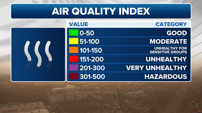
AQI Levels Explainer
(FOX Weather)
WHICH CITIES IN US HAVE WORST AIR QUALITY? NEW REPORT HIGHLIGHTS ALARMING GLOBAL TRENDS
According to the latest North American Drought Monitor, only 7% of Canada is currently experiencing drought conditions, which is down significantly from around 40% during the same period in 2024.
Canadian authorities do not expect drought conditions to worsen significantly in the short term, as a series of weak storm systems are forecast to bring scattered rain showers over the next week.
However, any system capable of producing thunderstorms brings an additional threat – lightning, which can spark new fires that can kindle for days before spreading.
[og_img
2025-06-01 00:16:58