
Storm Prediction Center Mesoscale Discussion 845
2 min read|
|
| Mesoscale Discussion 845 | |
| < Previous MD Next MD > | |
|
|
Mesoscale Discussion 0845
NWS Storm Prediction Center Norman OK
0641 PM CDT Sat May 17 2025
Areas affected...Ark-La-Tex
Concerning...Severe potential...Watch likely
Valid 172341Z - 180215Z
Probability of Watch Issuance...80 percent
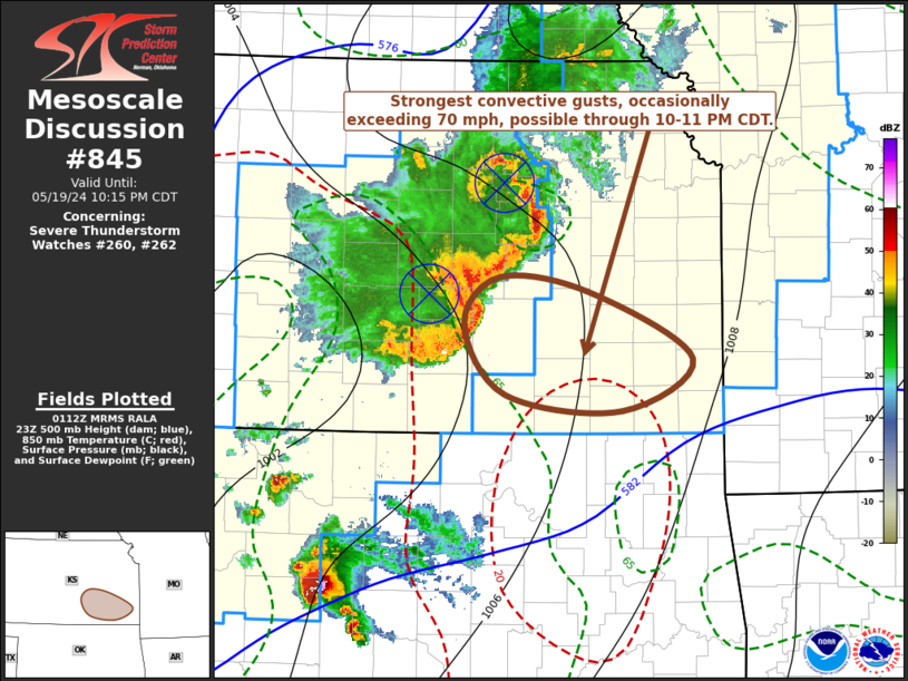
SUMMARY...A wind-damage, large hail and isolated tornado threat is
expected to develop across parts of the Ark-La-Tex early this
evening. Weather watch issuance will likely be needed.
DISCUSSION...The latest radar imagery from Fort Worth, Texas shows
multiple clusters of severe storms across northeast Texas. The
storms are located along the western edge of a pocket of strong to
extreme instability, where the RAP has MLCAPE in the 4500 to 5500
J/kg range. Water vapor imagery suggests that a shortwave trough is
moving through north-central Texas. Large-scale ascent associated
with this feature will support the continued development of strong
thunderstorms. Short-term forecasts, including the HRRR, move these
storms east-northeastward into the Ark-La-Tex over the next few
hours. In the Ark-La-Tex, the latest RAP shows steep low-level lapse
rates between 7.5 and 8 C/km, along with moderate deep-layer shear.
This is evident on the Shreveport WSR-88D VWP which has 0-6 km shear
near 50 knots. This environment will likely be favorable for a
severe threat with wind damage and large hail possible. An isolated
tornado could also develop.
..Broyles.. 05/17/2025
...Please see www.spc.noaa.gov for graphic product...
ATTN...WFO...LZK...SHV...TSA...FWD...
LAT...LON 34629278 34869367 34859443 34459505 33629536 32869518
32519454 32399371 32509288 33039236 33749216 34299225
34629278
MOST PROBABLE PEAK TORNADO INTENSITY...100-130 MPH
MOST PROBABLE PEAK WIND GUST...65-80 MPH
MOST PROBABLE PEAK HAIL SIZE...1.50-2.50 IN
|
|
|
Top/All Mesoscale Discussions/Forecast Products/Home |
|
2025-05-18 00:02:03
