
Storm Prediction Center Tornado Watch 234
3 min read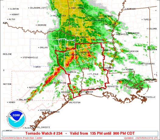

Note:
The expiration time in the watch graphic is amended if the watch is
replaced, cancelled or extended.
Note: Click for Watch Status Reports.
   SEL4

   URGENT - IMMEDIATE BROADCAST REQUESTED
   Tornado Watch Number 234
   NWS Storm Prediction Center Norman OK
   135 PM CDT Tue May 6 2025

   The NWS Storm Prediction Center has issued a

   * Tornado Watch for portions of
     Louisiana
     East Texas

   * Effective this Tuesday afternoon and evening from 135 PM until
     900 PM CDT.

   * Primary threats include...
     A few tornadoes likely with a couple intense tornadoes possible
     Scattered damaging winds likely with isolated significant gusts
       to 75 mph possible
     Isolated very large hail events to 2 inches in diameter possible

   SUMMARY...A line of thunderstorms with embedded supercells will
   spread eastward over east Texas into Louisiana this afternoon and
   evening. Main threats will be tornadoes and severe/damaging winds. A
   strong tornado or two will be possible with any supercell that can
   persist along/ahead of the ongoing thunderstorms. Isolated large
   hail may also occur.

   The tornado watch area is approximately along and 90 statute miles
   north and south of a line from 10 miles west southwest of Lufkin TX
   to 25 miles northeast of Alexandria LA. For a complete depiction of
   the watch see the associated watch outline update (WOUS64 KWNS
   WOU4).

   PRECAUTIONARY/PREPAREDNESS ACTIONS...

   REMEMBER...A Tornado Watch means conditions are favorable for
   tornadoes and severe thunderstorms in and close to the watch
   area. Persons in these areas should be on the lookout for
   threatening weather conditions and listen for later statements
   and possible warnings.

   &&

   OTHER WATCH INFORMATION...CONTINUE...WW 231...WW 232...WW 233...

   AVIATION...Tornadoes and a few severe thunderstorms with hail
   surface and aloft to 2 inches. Extreme turbulence and surface wind
   gusts to 65 knots. A few cumulonimbi with maximum tops to 500. Mean
   storm motion vector 24035.

   ...Gleason

2025-05-06 18:35:03
