
Storm Prediction Center Severe Thunderstorm Watch 233
3 min read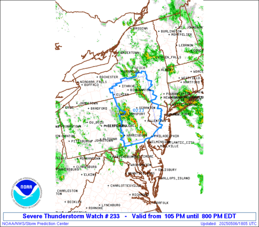

Note:
The expiration time in the watch graphic is amended if the watch is
replaced, cancelled or extended.
Note: Click for Watch Status Reports.
   SEL3

   URGENT - IMMEDIATE BROADCAST REQUESTED
   Severe Thunderstorm Watch Number 233
   NWS Storm Prediction Center Norman OK
   105 PM EDT Tue May 6 2025

   The NWS Storm Prediction Center has issued a

   * Severe Thunderstorm Watch for portions of
     Western and Northern New Jersey
     South-Central New York
     Eatsern Pennsylvania

   * Effective this Tuesday afternoon and evening from 105 PM until
     800 PM EDT.

   * Primary threats include...
     Scattered damaging wind gusts to 70 mph possible
     Scattered large hail events to 1.5 inches in diameter possible

   SUMMARY...Thunderstorms should continue to increase in coverage and
   intensity this afternoon as they move generally northward. The
   strongest thunderstorms could produce hail up to 1-1.5 inches in
   diameter and damaging winds with peak gusts to 60-70 mph.

   The severe thunderstorm watch area is approximately along and 55
   statute miles east and west of a line from 35 miles north northeast
   of Binghamton NY to 35 miles west of Philadelphia PA. For a complete
   depiction of the watch see the associated watch outline update
   (WOUS64 KWNS WOU3).

   PRECAUTIONARY/PREPAREDNESS ACTIONS...

   REMEMBER...A Severe Thunderstorm Watch means conditions are
   favorable for severe thunderstorms in and close to the watch area.
   Persons in these areas should be on the lookout for threatening
   weather conditions and listen for later statements and possible
   warnings. Severe thunderstorms can and occasionally do produce
   tornadoes.

   &&

   OTHER WATCH INFORMATION...CONTINUE...WW 231...WW 232...

   AVIATION...A few severe thunderstorms with hail surface and aloft to
   1.5 inches. Extreme turbulence and surface wind gusts to 60 knots. A
   few cumulonimbi with maximum tops to 450. Mean storm motion vector
   19030.

   ...Gleason

2025-05-06 17:05:03
