
Storm Prediction Center Severe Thunderstorm Watch 219
3 min read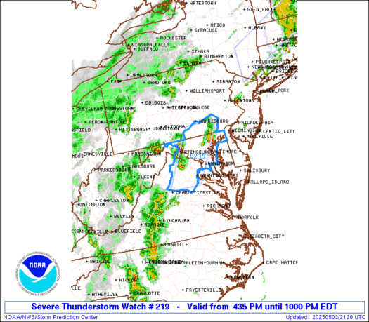

Note:
The expiration time in the watch graphic is amended if the watch is
replaced, cancelled or extended.
Note: Click for Watch Status Reports.
   SEL9

   URGENT - IMMEDIATE BROADCAST REQUESTED
   Severe Thunderstorm Watch Number 219
   NWS Storm Prediction Center Norman OK
   435 PM EDT Sat May 3 2025

   The NWS Storm Prediction Center has issued a

   * Severe Thunderstorm Watch for portions of
     District Of Columbia
     Central into Northeast Maryland
     Southeast Pennsylvania
     Northern Virginia
     The Far Eastern West Virginia Panhandle
     Coastal Waters

   * Effective this Saturday afternoon and evening from 435 PM until
     1000 PM EDT.

   * Primary threats include...
     Scattered damaging wind gusts to 70 mph possible
     Scattered large hail events to 1.5 inches in diameter possible
     A tornado or two possible

   SUMMARY...Isolated to widely scattered supercells should pose some
   threat for severe hail around 1-1.5 inches in diameter and damaging
   winds late this afternoon into the evening. A tornado or two may
   also occur.

   The severe thunderstorm watch area is approximately along and 35
   statute miles east and west of a line from 65 miles north of
   Baltimore MD to 65 miles southwest of Washington DC. For a complete
   depiction of the watch see the associated watch outline update
   (WOUS64 KWNS WOU9).

   PRECAUTIONARY/PREPAREDNESS ACTIONS...

   REMEMBER...A Severe Thunderstorm Watch means conditions are
   favorable for severe thunderstorms in and close to the watch area.
   Persons in these areas should be on the lookout for threatening
   weather conditions and listen for later statements and possible
   warnings. Severe thunderstorms can and occasionally do produce
   tornadoes.

   &&

   OTHER WATCH INFORMATION...CONTINUE...WW 218...

   AVIATION...A few severe thunderstorms with hail surface and aloft to
   1.5 inches. Extreme turbulence and surface wind gusts to 60 knots. A
   few cumulonimbi with maximum tops to 450. Mean storm motion vector
   24035.

   ...Gleason

2025-05-03 20:35:03


