
Storm Prediction Center Mesoscale Discussion 665
1 min read|
|
| Mesoscale Discussion 665 | |
| < Previous MD | |
|
|
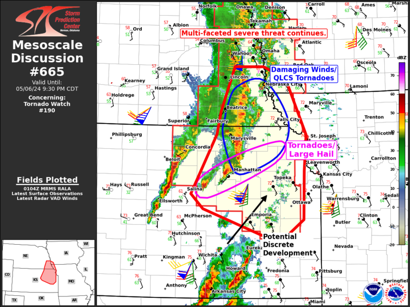
   Mesoscale Discussion 0665
   NWS Storm Prediction Center Norman OK
   1114 AM CDT Sat May 03 2025

   Areas affected...parts of the Northeast and southern New England

   Concerning...Severe potential...Severe Thunderstorm Watch likely

   Valid 031614Z - 031815Z

   Probability of Watch Issuance...80 percent

   SUMMARY...An increasing severe threat is expected through the
   afternoon across a confined corridor of the Northeast and southern
   New England. A mix of at least isolated damaging winds and hail is
   anticipated. A severe thunderstorm watch issuance appears likely.

   DISCUSSION...Bulk of morning guidance, outside of the HRRR and
   parent RAP, suggest a favorable corridor of at least isolated severe
   storms should develop from the PA/NJ/NY border northeastward across
   parts of interior southern New England. Robust boundary-layer
   heating is underway ahead of the minor lobe of ascent over eastern
   PA and south of the quasi-stationary front. The differential heating
   across the front will aid in strengthening the baroclinic zone.
   While mid-level lapse rates are weak and will temper overall storm
   intensity, nearly unidirectional southwesterly wind profiles with
   moderate speed shear will foster occasional updraft rotation. A mix
   of cells and small clusters should support both a severe hail/wind
   threat in a confined corridor through the afternoon.

   ..Grams/Gleason.. 05/03/2025

   ...Please see www.spc.noaa.gov for graphic product...

   ATTN...WFO...GYX...BOX...OKX...ALY...PHI...BGM...

   LAT...LON   41187498 42107438 42727332 43327208 43437130 43187092
               42597125 41777276 41177389 40647457 40437498 40537542
               41187498

   MOST PROBABLE PEAK TORNADO INTENSITY...UP TO 95 MPH
   MOST PROBABLE PEAK WIND GUST...55-70 MPH
   MOST PROBABLE PEAK HAIL SIZE...1.00-1.75 IN
|
|
|
Top/All Mesoscale Discussions/Forecast Products/Home |
|
2025-05-03 16:32:02


