
Storm Prediction Center Mesoscale Discussion 640
2 min read|
|
| Mesoscale Discussion 640 | |
| < Previous MD Next MD > | |
|
|
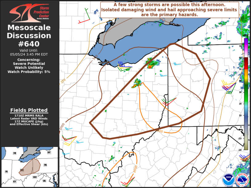
Mesoscale Discussion 0640 NWS Storm Prediction Center Norman OK 0906 PM CDT Thu May 01 2025 Areas affected...Central Pennsylvania Concerning...Severe Thunderstorm Watch 206... Valid 020206Z - 020400Z The severe weather threat for Severe Thunderstorm Watch 206 continues. SUMMARY...A severe wind threat may persist for the next 1-2 hours across central Pennsylvania, but a general weakening trend is expected through 03 UTC amid the onset of nocturnal cooling. DISCUSSION...Recent surface observations and RAP analyses show an expansive cold pool in place across central PA in the wake of a thunderstorm cluster earlier this evening. However, VWP observations from KCCX continue to show strong warm advection within the lowest 1-2 km AGL, which is not only supporting 0-1 km SRH on the order of 200-300 m2/s2, but is also maintaining modest warm/moist advection into the region from the south/southeast where dewpoints remain in the low to mid 60s. Consequently, sufficient buoyancy remains in place across the region to support deep convection - as evidenced by cooling cloud top temperatures and increasing echo tops over the past 30 minutes. Given sufficient (albeit limited) buoyancy and strong low-level wind shear, storm organization remains possible with an attendant threat for damaging winds in the near term across central PA. Beyond 03 UTC, confidence in this threat wanes as nocturnal cooling will continue to promote increasing low-level inhibition and diminishing buoyancy. ..Moore.. 05/02/2025 ...Please see www.spc.noaa.gov for graphic product... ATTN...WFO...CTP... LAT...LON 39977890 40737876 41077846 41267808 41267763 41047722 40687715 40337716 39987738 39797769 39747837 39807876 39977890 MOST PROBABLE PEAK WIND GUST...55-70 MPH |
|
|
Top/All Mesoscale Discussions/Forecast Products/Home |
|
2025-05-02 02:16:03


