
SPC MD 642
2 min read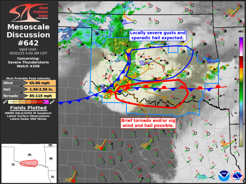
MD 0642 CONCERNING SEVERE THUNDERSTORM WATCH 208… FOR MUCH OF SOUTHERN AND CENTRAL OKLAHOMA…FAR NORTHERN TEXAS
Mesoscale Discussion 0642
NWS Storm Prediction Center Norman OK
0203 AM CDT Fri May 02 2025

Areas affected...much of southern and central Oklahoma...far
northern Texas

Concerning...Severe Thunderstorm Watch 208...

Valid 020703Z - 020900Z

The severe weather threat for Severe Thunderstorm Watch 208
continues.

SUMMARY...The threat of severe gusts and hail remains over the
entire watch area, with brief tornadoes, sporadic very large hail,
and perhaps locally significant gusts over southern Oklahoma and
along the Red River Valley.

DISCUSSION...Storms have rapidly increased in coverage across much
of western through southern OK, as the influence of the upper trough
and cooling aloft overspread the moist and unstable air mass. The
greatest threat area should continue to be over southern parts of
the watch, in proximity to the stationary front. Here, both
moisture, instability and convergence are maximized. Very large
storms have evolved out of this developing cluster, with new cells
just east of the primary supercell. Given the strong instability,
low-level shear may be sufficient to support periodic mesocyclones
and brief tornadoes. The primary risk will more likely be damaging
wind and hail, both of which could be locally significant.

For northern areas, the storms associated with the cold pool surge
out of the west may continue to produce at least near-severe gusts.
Although the low-level jet is not strong this evening, a very slow
northward push of elevated moisture, coupled with steep lapse rates
aloft, could conceivably aid some strengthening over time.

..Jewell.. 05/02/2025

...Please see www.spc.noaa.gov for graphic product...

ATTN...WFO...TSA...FWD...OUN...

LAT...LON   33829828 33899865 33999885 34189891 34409871 34569771
            34589721 34669616 34499590 34159578 33819605 33659635
            33739762 33829828

MOST PROBABLE PEAK TORNADO INTENSITY...85-115 MPH
MOST PROBABLE PEAK WIND GUST...65-80 MPH
MOST PROBABLE PEAK HAIL SIZE...1.50-2.50 IN
Read more
[og_img]
2025-05-02 07:34:03


