Storm Prediction Center Severe Thunderstorm Watch 202
4 min read
4 months ago
Note:
The expiration time in the watch graphic is amended if the watch is
replaced, cancelled or extended. Note: Click for Watch Status Reports.
SEL2
URGENT - IMMEDIATE BROADCAST REQUESTED
Severe Thunderstorm Watch Number 202
NWS Storm Prediction Center Norman OK
750 PM CDT Wed Apr 30 2025
The NWS Storm Prediction Center has issued a
* Severe Thunderstorm Watch for portions of
Central into East Texas
* Effective this Wednesday night from 750 PM until Midnight CDT.
* Primary threats include...
Scattered damaging wind gusts to 70 mph possible
Scattered large hail events to 1.5 inches in diameter possible
SUMMARY...A strong to severe thunderstorm cluster will likely
continue to pose a risk for mainly severe gusts and large hail
through the evening, from eastern portions of central Texas into
east Texas.
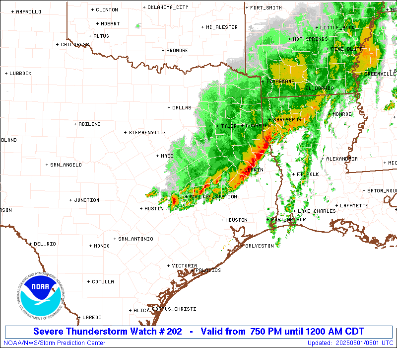
The severe thunderstorm watch area is approximately along and 45
statute miles north and south of a line from 15 miles south of
Temple TX to 50 miles east northeast of Lufkin TX. For a complete
depiction of the watch see the associated watch outline update
(WOUS64 KWNS WOU2).
PRECAUTIONARY/PREPAREDNESS ACTIONS...
REMEMBER...A Severe Thunderstorm Watch means conditions are
favorable for severe thunderstorms in and close to the watch area.
Persons in these areas should be on the lookout for threatening
weather conditions and listen for later statements and possible
warnings. Severe thunderstorms can and occasionally do produce
tornadoes.
&&
OTHER WATCH INFORMATION...CONTINUE...WW 198...WW 199...WW
200...WW 201...
AVIATION...A few severe thunderstorms with hail surface and aloft to
1.5 inches. Extreme turbulence and surface wind gusts to 60 knots. A
few cumulonimbi with maximum tops to 500. Mean storm motion vector
27035.
...Smith
   SEL2

   URGENT - IMMEDIATE BROADCAST REQUESTED
   Severe Thunderstorm Watch Number 202
   NWS Storm Prediction Center Norman OK
   750 PM CDT Wed Apr 30 2025

   The NWS Storm Prediction Center has issued a

   * Severe Thunderstorm Watch for portions of
     Central into East Texas

   * Effective this Wednesday night from 750 PM until Midnight CDT.

   * Primary threats include...
     Scattered damaging wind gusts to 70 mph possible
     Scattered large hail events to 1.5 inches in diameter possible

   SUMMARY...A strong to severe thunderstorm cluster will likely
   continue to pose a risk for mainly severe gusts and large hail
   through the evening, from eastern portions of central Texas into
   east Texas.

   The severe thunderstorm watch area is approximately along and 45
   statute miles north and south of a line from 15 miles south of
   Temple TX to 50 miles east northeast of Lufkin TX. For a complete
   depiction of the watch see the associated watch outline update
   (WOUS64 KWNS WOU2).

   PRECAUTIONARY/PREPAREDNESS ACTIONS...

   REMEMBER...A Severe Thunderstorm Watch means conditions are
   favorable for severe thunderstorms in and close to the watch area.
   Persons in these areas should be on the lookout for threatening
   weather conditions and listen for later statements and possible
   warnings. Severe thunderstorms can and occasionally do produce
   tornadoes.

   &&

   OTHER WATCH INFORMATION...CONTINUE...WW 198...WW 199...WW
   200...WW 201...

   AVIATION...A few severe thunderstorms with hail surface and aloft to
   1.5 inches. Extreme turbulence and surface wind gusts to 60 knots. A
   few cumulonimbi with maximum tops to 500. Mean storm motion vector
   27035.

   ...Smith
Note:
The Aviation Watch (SAW) product is an approximation to the watch area.
The actual watch is depicted by the shaded areas.
   SAW2
   WW 202 SEVERE TSTM TX 010050Z - 010500Z
   AXIS..45 STATUTE MILES NORTH AND SOUTH OF LINE..
   15S TPL/TEMPLE TX/ - 50ENE LFK/LUFKIN TX/
   ..AVIATION COORDS.. 40NM N/S /34N CWK - 44ENE LFK/
   HAIL SURFACE AND ALOFT..1.5 INCHES. WIND GUSTS..60 KNOTS.
   MAX TOPS TO 500. MEAN STORM MOTION VECTOR 27035.

   LAT...LON 31589742 32169397 30859397 30289742

   THIS IS AN APPROXIMATION TO THE WATCH AREA.  FOR A
   COMPLETE DEPICTION OF THE WATCH SEE WOUS64 KWNS
   FOR WOU2.
Watch 202 Status Report Messages:
STATUS REPORT #1 ON WW 202

VALID 010135Z - 010240Z

THE SEVERE WEATHER THREAT CONTINUES ACROSS THE ENTIRE WATCH AREA.

FOR ADDITIONAL INFORMATION SEE MESOSCALE DISCUSSION 628

..WEINMAN..05/01/25

ATTN...WFO...FWD...SHV...HGX...

&&

STATUS REPORT FOR WS 202

SEVERE WEATHER THREAT CONTINUES FOR THE FOLLOWING AREAS

TXC001-005-027-041-051-073-145-161-185-225-289-293-313-331-347-
395-405-419-455-471-477-010240-

TX
.    TEXAS COUNTIES INCLUDED ARE

ANDERSON	     ANGELINA		 BELL
BRAZOS		     BURLESON		 CHEROKEE
FALLS		     FREESTONE		 GRIMES
HOUSTON 	     LEON		 LIMESTONE
MADISON 	     MILAM		 NACOGDOCHES
ROBERTSON	     SAN AUGUSTINE	 SHELBY
TRINITY 	     WALKER		 WASHINGTON
$$


THE WATCH STATUS MESSAGE IS FOR GUIDANCE PURPOSES ONLY.  PLEASE
REFER TO WATCH COUNTY NOTIFICATION STATEMENTS FOR OFFICIAL
INFORMATION ON COUNTIES...INDEPENDENT CITIES AND MARINE ZONES
CLEARED FROM SEVERE THUNDERSTORM AND TORNADO WATCHES.
$$
Probability of 1 or more strong (EF2-EF5) tornadoes
Low (5%)
Wind
Probability of 10 or more severe wind events
Mod (40%)
Probability of 1 or more wind events > 65 knots
Low (20%)
Hail
Probability of 10 or more severe hail events
Mod (40%)
Probability of 1 or more hailstones > 2 inches
Low (20%)
Combined Severe Hail/Wind
Probability of 6 or more combined severe hail/wind events
High (70%)
For each watch, probabilities for particular events inside the watch
(listed above in each table) are determined by the issuing forecaster.
The “Low” category contains probability values ranging from less than 2%
to 20% (EF2-EF5 tornadoes), less than 5% to 20% (all other probabilities),
“Moderate” from 30% to 60%, and “High” from 70% to greater than 95%.
High values are bolded and lighter in color to provide awareness of
an increased threat for a particular event.