
Storm Prediction Center Tornado Watch 197
3 min read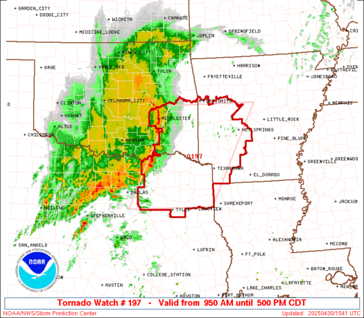
Note:
The expiration time in the watch graphic is amended if the watch is
replaced, cancelled or extended.
Note: Click for Watch Status Reports.
   SEL7

   URGENT - IMMEDIATE BROADCAST REQUESTED
   Tornado Watch Number 197
   NWS Storm Prediction Center Norman OK
   950 AM CDT Wed Apr 30 2025

   The NWS Storm Prediction Center has issued a

   * Tornado Watch for portions of
     Western Arkansas
     Southeast Oklahoma
     Northeast Texas

   * Effective this Wednesday morning and afternoon from 950 AM
     until 500 PM CDT.

   * Primary threats include...
     A few tornadoes likely with a couple intense tornadoes possible
     Scattered damaging wind gusts to 70 mph likely
     Scattered large hail events to 1.5 inches in diameter possible

   SUMMARY...A line of thunderstorms over southern Oklahoma and north
   Texas will track eastward today across the watch area.  Locally
   damaging wind gusts are possible along the line along with brief
   tornadoes.  Other severe storms capable of tornadoes may form ahead
   of the line by early afternoon.

   The tornado watch area is approximately along and 80 statute miles
   east and west of a line from 40 miles east northeast of Poteau OK to
   85 miles south of Paris TX. For a complete depiction of the watch
   see the associated watch outline update (WOUS64 KWNS WOU7).

   PRECAUTIONARY/PREPAREDNESS ACTIONS...

   REMEMBER...A Tornado Watch means conditions are favorable for
   tornadoes and severe thunderstorms in and close to the watch
   area. Persons in these areas should be on the lookout for
   threatening weather conditions and listen for later statements
   and possible warnings.

   &&

   AVIATION...Tornadoes and a few severe thunderstorms with hail
   surface and aloft to 1.5 inches. Extreme turbulence and surface wind
   gusts to 60 knots. A few cumulonimbi with maximum tops to 500. Mean
   storm motion vector 24030.

   ...Hart

2025-04-30 14:50:02

