Note:
The expiration time in the watch graphic is amended if the watch is
replaced, cancelled or extended. Note: Click for Watch Status Reports.
SEL4
URGENT - IMMEDIATE BROADCAST REQUESTED
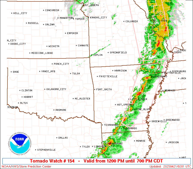
Tornado Watch Number 154
NWS Storm Prediction Center Norman OK
1200 PM CDT Sun Apr 20 2025
The NWS Storm Prediction Center has issued a
* Tornado Watch for portions of
western and central Arkansas
southeastern Kansas
northwestern Louisiana
central and southern Missouri
eastern Oklahoma
far northeastern Texas
* Effective this Sunday afternoon and evening from NOON until 700
PM CDT.
* Primary threats include...
Several tornadoes likely with a couple intense tornadoes
possible
Scattered damaging wind gusts to 70 mph likely
Scattered large hail events to 1.5 inches in diameter possible
SUMMARY...A steady increase in coverage and intensity of
thunderstorms is expected to occur over the next several hours, with
severe-weather potential evolving from eastern Oklahoma and the
Arklatex region northward into Missouri. Along with risk for fairly
widespread damaging wind gusts and hail, several tornadoes are
expected -- including potential for a few that are
strong/longer-lived.
The tornado watch area is approximately along and 75 statute miles
east and west of a line from 45 miles north of Springfield MO to 25
miles west of Texarkana AR. For a complete depiction of the watch
see the associated watch outline update (WOUS64 KWNS WOU4).
PRECAUTIONARY/PREPAREDNESS ACTIONS...
REMEMBER...A Tornado Watch means conditions are favorable for
tornadoes and severe thunderstorms in and close to the watch
area. Persons in these areas should be on the lookout for
threatening weather conditions and listen for later statements
and possible warnings.
&&
AVIATION...Tornadoes and a few severe thunderstorms with hail
surface and aloft to 1.5 inches. Extreme turbulence and surface wind
gusts to 60 knots. A few cumulonimbi with maximum tops to 500. Mean
storm motion vector 23040.
...Goss
   SEL4

   URGENT - IMMEDIATE BROADCAST REQUESTED
   Tornado Watch Number 154
   NWS Storm Prediction Center Norman OK
   1200 PM CDT Sun Apr 20 2025

   The NWS Storm Prediction Center has issued a

   * Tornado Watch for portions of
     western and central Arkansas
     southeastern Kansas
     northwestern Louisiana
     central and southern Missouri
     eastern Oklahoma
     far northeastern Texas

   * Effective this Sunday afternoon and evening from NOON until 700
     PM CDT.

   * Primary threats include...
     Several tornadoes likely with a couple intense tornadoes
       possible
     Scattered damaging wind gusts to 70 mph likely
     Scattered large hail events to 1.5 inches in diameter possible

   SUMMARY...A steady increase in coverage and intensity of
   thunderstorms is expected to occur over the next several hours, with
   severe-weather potential evolving from eastern Oklahoma and the
   Arklatex region northward into Missouri.  Along with risk for fairly
   widespread damaging wind gusts and hail, several tornadoes are
   expected -- including potential for a few that are
   strong/longer-lived.

   The tornado watch area is approximately along and 75 statute miles
   east and west of a line from 45 miles north of Springfield MO to 25
   miles west of Texarkana AR. For a complete depiction of the watch
   see the associated watch outline update (WOUS64 KWNS WOU4).

   PRECAUTIONARY/PREPAREDNESS ACTIONS...

   REMEMBER...A Tornado Watch means conditions are favorable for
   tornadoes and severe thunderstorms in and close to the watch
   area. Persons in these areas should be on the lookout for
   threatening weather conditions and listen for later statements
   and possible warnings.

   &&

   AVIATION...Tornadoes and a few severe thunderstorms with hail
   surface and aloft to 1.5 inches. Extreme turbulence and surface wind
   gusts to 60 knots. A few cumulonimbi with maximum tops to 500. Mean
   storm motion vector 23040.

   ...Goss
Note:
The Aviation Watch (SAW) product is an approximation to the watch area.
The actual watch is depicted by the shaded areas.
   SAW4
   WW 154 TORNADO AR KS LA MO OK TX 201700Z - 210000Z
   AXIS..75 STATUTE MILES EAST AND WEST OF LINE..
   45N SGF/SPRINGFIELD MO/ - 25W TXK/TEXARKANA AR/
   ..AVIATION COORDS.. 65NM E/W /31N SGF - 19W TXK/
   HAIL SURFACE AND ALOFT..1.5 INCHES. WIND GUSTS..60 KNOTS.
   MAX TOPS TO 500. MEAN STORM MOTION VECTOR 23040.

   LAT...LON 37869201 33439313 33439573 37869475

   THIS IS AN APPROXIMATION TO THE WATCH AREA.  FOR A
   COMPLETE DEPICTION OF THE WATCH SEE WOUS64 KWNS
   FOR WOU4.
Watch 154 Status Report Message has not been issued yet.
Probability of 1 or more strong (EF2-EF5) tornadoes
Mod (50%)
Wind
Probability of 10 or more severe wind events
Mod (60%)
Probability of 1 or more wind events > 65 knots
Low (20%)
Hail
Probability of 10 or more severe hail events
Mod (40%)
Probability of 1 or more hailstones > 2 inches
Low (10%)
Combined Severe Hail/Wind
Probability of 6 or more combined severe hail/wind events
High (>95%)
For each watch, probabilities for particular events inside the watch
(listed above in each table) are determined by the issuing forecaster.
The “Low” category contains probability values ranging from less than 2%
to 20% (EF2-EF5 tornadoes), less than 5% to 20% (all other probabilities),
“Moderate” from 30% to 60%, and “High” from 70% to greater than 95%.
High values are bolded and lighter in color to provide awareness of
an increased threat for a particular event.