
Storm Prediction Center Mesoscale Discussion 452
1 min read|
|
| Mesoscale Discussion 452 | |
| < Previous MD | |
|
|
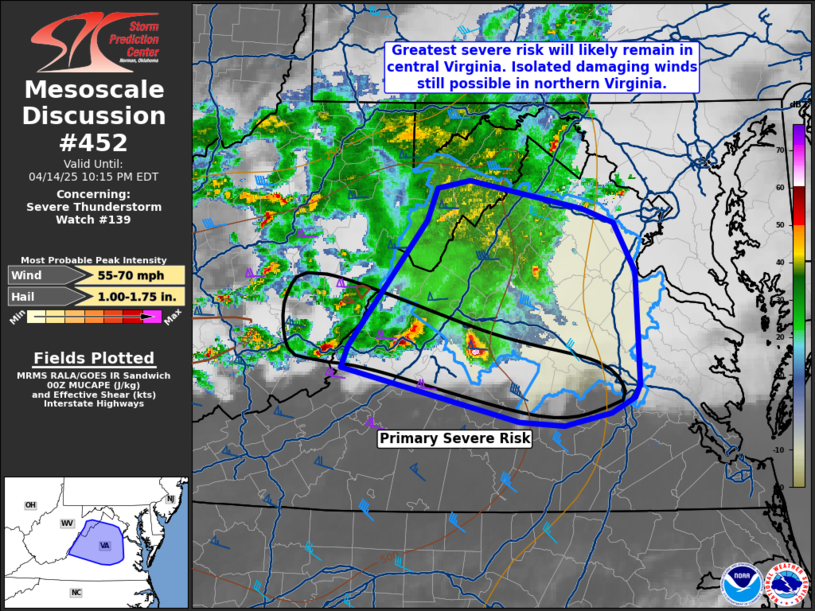
Mesoscale Discussion 0452 NWS Storm Prediction Center Norman OK 0740 PM CDT Mon Apr 14 2025 Areas affected...Northern and central Virginia Concerning...Severe Thunderstorm Watch 139... Valid 150040Z - 150215Z The severe weather threat for Severe Thunderstorm Watch 139 continues. SUMMARY...The primary corridor for large hail and damaging winds will exist along the southern edge of WW 139 in central Virginia. Farther north, isolated strong/damaging winds remain possible. DISCUSSION...The primary corridor of severe risk will likely be within parts of central Virginia this evening. A supercell currently in Nelson County will be capable of large hail and damaging winds. This lead supercell has shown a tendency to move more east-northeast the last half hour, suggesting it may be transitioning to being slightly elevated. Even so, MRMS data suggests large hail is occurring. Other strong to severe storms are training behind the lead supercell and will also pose a threat for large hail and damaging winds. In northern Virginia, temperatures have diabatically cooled as broad area of precipitation has overspread the area. Some elevated instability still remains and the KRLX VAD showed 35-45 kts of flow behind the passing convection. With the Dulles 00Z observed sounding showing 7 C/km lapse rates and a dry sub-cloud layer, a strong/damaging gust could still occur where any convective cores develop. ..Wendt.. 04/15/2025 ...Please see www.spc.noaa.gov for graphic product... ATTN...WFO...AKQ...LWX...RNK... LAT...LON 37828011 38817934 39067924 39127892 38897781 38797749 38417729 37537725 37427730 37307752 37207799 37237843 37658017 37828011 MOST PROBABLE PEAK WIND GUST...55-70 MPH MOST PROBABLE PEAK HAIL SIZE...1.00-1.75 IN |
|
|
Top/All Mesoscale Discussions/Forecast Products/Home |
|
2025-04-15 00:55:02


