
Storm Prediction Center Mesoscale Discussion 446
1 min read|
|
| Mesoscale Discussion 446 | |
| < Previous MD | |
|
|
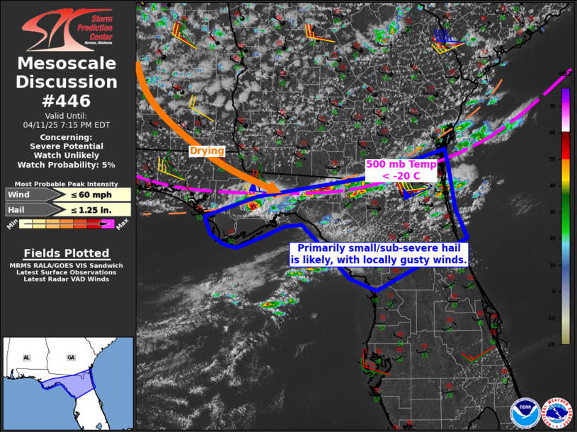
   Mesoscale Discussion 0446
   NWS Storm Prediction Center Norman OK
   0351 PM CDT Fri Apr 11 2025

   Areas affected...northern Florida

   Concerning...Severe potential...Watch unlikely

   Valid 112051Z - 112315Z

   Probability of Watch Issuance...5 percent

   SUMMARY...Several storms may produce small hail and locally gusty
   winds through late afternoon.

   DISCUSSION...Surface temperatures have risen into the upper 70s to
   near 80 F this afternoon, as temperatures aloft continue to cool. A
   very steep lapse rate environment has developed with 500 mb
   temperature to -20 C into parts of the FL Panhandle and northern FL.


   A few thunderstorms have already formed along the surface trough
   extending from the Panhandle into extreme southeast GA, with
   indications of small/non-severe hail. Moisture is the limiting
   factor to storm severity today, with low dewpoints spreading
   southward. Even so, convective coverage may continue to increase
   over the next couple hours as lapse rates are maximized. Although
   low PWAT overall, the deepened boundary layer along with low
   freezing levels and lengthy hodographs will work together to produce
   primarily non-severe hail. Boundary layer winds remain relatively
   weak, therefore any strong to potentially damaging gust would likely
   be localized (but possibly aided by cold hail-laden outflow).

   ..Jewell/Gleason.. 04/11/2025

   ...Please see www.spc.noaa.gov for graphic product...

   ATTN...WFO...TBW...JAX...TAE...

   LAT...LON   30028555 30338467 30628282 31068144 30828138 30158126
               29728107 28948262 29128307 29598353 29928389 29898419
               29768449 29568500 29628522 29768546 30028555

   MOST PROBABLE PEAK WIND GUST...UP TO 60 MPH
   MOST PROBABLE PEAK HAIL SIZE...UP TO 1.25 IN
|
|
|
Top/All Mesoscale Discussions/Forecast Products/Home |
|
2025-04-11 20:53:08

