
Storm Prediction Center Mesoscale Discussion 376
1 min read|
|
| Mesoscale Discussion 376 | |
| < Previous MD Next MD > | |
|
|
Mesoscale Discussion 0376
NWS Storm Prediction Center Norman OK
0855 AM CDT Thu Apr 03 2025
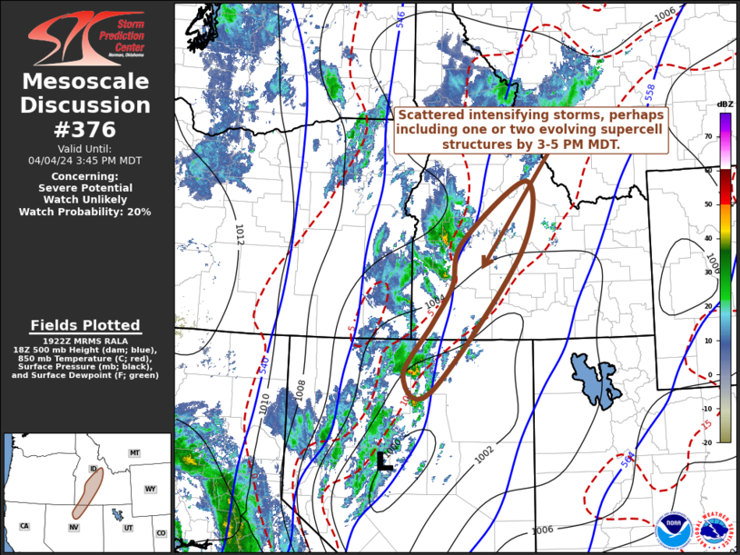
Areas affected...South-central into southeast OK
Concerning...Severe potential...Watch unlikely
Valid 031355Z - 031530Z
Probability of Watch Issuance...20 percent
SUMMARY...A threat for isolated severe gusts and hail will spread
northeastward this morning. The longevity of the morning threat
remains uncertain.
DISCUSSION...Despite being elevated above an outflow-reinforced
front draped across north TX, a bowing segment has recently produced
several severe gusts ranging from 63-72 mph across south-central OK.
This bowing segment is moving along the gradient of elevated
buoyancy, with MUCAPE of 500-1000 J/kg and strong effective shear
(greater than 50 kt) providing a favorable environment for
maintenance of this bow as it moves east-northeastward.
Given its elevated nature and location near the gradient of
favorable MUCAPE, the longevity of the severe threat with this
bowing segment is uncertain. However, a threat for severe gusts and
isolated hail through at least mid morning. If this storm cluster
and bowing segment can keep pace with returning deeper moisture
above the surface, then it could persist later into the morning with
a continued severe threat.
..Dean/Guyer.. 04/03/2025
...Please see www.spc.noaa.gov for graphic product...
ATTN...WFO...SHV...TSA...OUN...
LAT...LON 34729700 35119641 35559522 34659475 34309476 33989611
33909661 33989655 34279676 34729700
MOST PROBABLE PEAK WIND GUST...55-70 MPH
MOST PROBABLE PEAK HAIL SIZE...1.00-1.75 IN
|
|
|
Top/All Mesoscale Discussions/Forecast Products/Home |
|
2025-04-03 14:43:06

