Note:
The expiration time in the watch graphic is amended if the watch is
replaced, cancelled or extended. Note: Click for Watch Status Reports.
SEL8
URGENT - IMMEDIATE BROADCAST REQUESTED
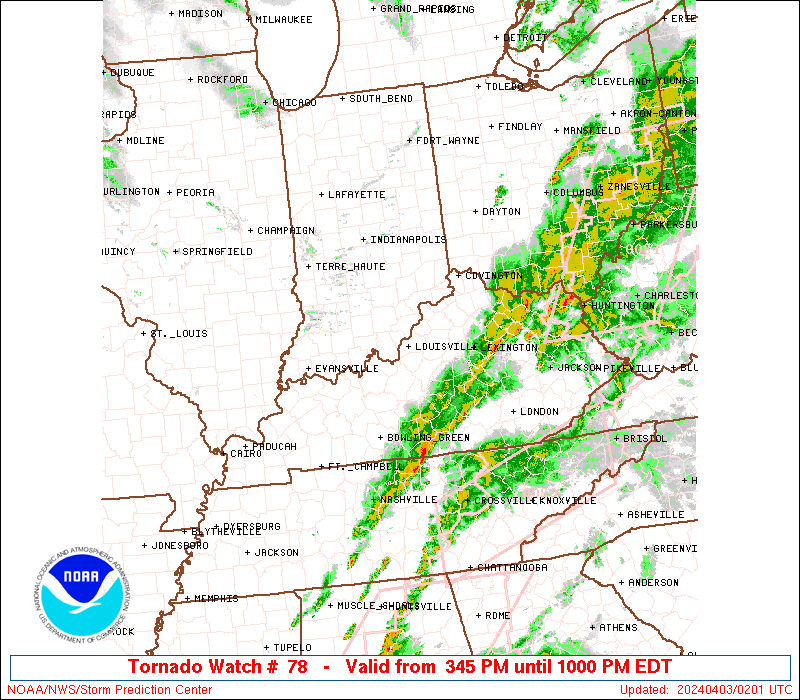
Tornado Watch Number 78
NWS Storm Prediction Center Norman OK
825 PM CDT Sun Mar 30 2025
The NWS Storm Prediction Center has issued a
* Tornado Watch for portions of
Central Kentucky
Western and Middle Tennessee
* Effective this Sunday night and Monday morning from 825 PM
until 300 AM CDT.
* Primary threats include...
A few tornadoes likely with a couple intense tornadoes possible
Scattered damaging wind gusts to 70 mph likely
Scattered large hail and isolated very large hail events to 2
inches in diameter possible
SUMMARY...Strong to severe thunderstorms are ongoing within a
convective line that extends from southern IN through western KY
into western TN. This line is expected to continue eastward into the
moist and moderately unstable airmass downstream across central KY
and western/middle TN. The environment supports a continuation of
the ongoing strong to severe storms. Persistent moderate to strong
low-level shear will support the potential for tornadoes embedded
within this line. Large hail and strong gusts are possible as well.
The tornado watch area is approximately along and 60 statute miles
east and west of a line from 45 miles northeast of Bowling Green KY
to 105 miles southwest of Nashville TN. For a complete depiction of
the watch see the associated watch outline update (WOUS64 KWNS
WOU8).
PRECAUTIONARY/PREPAREDNESS ACTIONS...
REMEMBER...A Tornado Watch means conditions are favorable for
tornadoes and severe thunderstorms in and close to the watch
area. Persons in these areas should be on the lookout for
threatening weather conditions and listen for later statements
and possible warnings.
&&
OTHER WATCH INFORMATION...CONTINUE...WW 72...WW 74...WW 75...WW
76...WW 77...
AVIATION...Tornadoes and a few severe thunderstorms with hail
surface and aloft to 2 inches. Extreme turbulence and surface wind
gusts to 60 knots. A few cumulonimbi with maximum tops to 500. Mean
storm motion vector 27040.
...Mosier
Note:
The Aviation Watch (SAW) product is an approximation to the watch area.
The actual watch is depicted by the shaded areas.
   SAW8
   WW 78 TORNADO KY TN 310125Z - 310800Z
   AXIS..60 STATUTE MILES EAST AND WEST OF LINE..
   45NE BWG/BOWLING GREEN KY/ - 105SW BNA/NASHVILLE TN/
   ..AVIATION COORDS.. 50NM E/W /41NE BWG - 33NW MSL/
   HAIL SURFACE AND ALOFT..2 INCHES. WIND GUSTS..60 KNOTS.
   MAX TOPS TO 500. MEAN STORM MOTION VECTOR 27040.

   LAT...LON 37418475 35048693 35048905 37418693

   THIS IS AN APPROXIMATION TO THE WATCH AREA.  FOR A
   COMPLETE DEPICTION OF THE WATCH SEE WOUS64 KWNS
   FOR WOU8.
Watch 78 Status Report Messages:
STATUS REPORT #1 ON WW 78

VALID 310445Z - 310540Z

SEVERE WEATHER THREAT CONTINUES RIGHT OF A LINE FROM 35 WSW MKL
TO 30 SSE CKV TO 50 SSE SDF AND 30 SW MKL TO 20 W BNA TO 45 SW
LEX.

..BROYLES..03/31/25

ATTN...WFO...LMK...MEG...OHX...

&&

STATUS REPORT FOR WT 78

SEVERE WEATHER THREAT CONTINUES FOR THE FOLLOWING AREAS

KYC001-003-045-053-057-137-169-171-207-310540-

KY
.    KENTUCKY COUNTIES INCLUDED ARE

ADAIR		     ALLEN		 CASEY
CLINTON 	     CUMBERLAND 	 LINCOLN
METCALFE	     MONROE		 RUSSELL
$$


TNC003-015-023-027-031-035-037-039-041-043-049-055-061-069-071-
077-081-087-099-101-109-111-117-119-133-135-137-141-149-159-165-
169-175-177-181-185-187-189-310540-

TN
.    TENNESSEE COUNTIES INCLUDED ARE

BEDFORD 	     CANNON		 CHESTER
CLAY		     COFFEE		 CUMBERLAND
DAVIDSON	     DECATUR		 DE KALB
DICKSON 	     FENTRESS		 GILES
GRUNDY		     HARDEMAN		 HARDIN
HENDERSON	     HICKMAN		 JACKSON
LAWRENCE	     LEWIS		 MCNAIRY
MACON		     MARSHALL		 MAURY
OVERTON 	     PERRY		 PICKETT
PUTNAM		     RUTHERFORD 	 SMITH
SUMNER		     TROUSDALE		 VAN BUREN
WARREN		     WAYNE		 WHITE
WILLIAMSON	     WILSON
$$


THE WATCH STATUS MESSAGE IS FOR GUIDANCE PURPOSES ONLY.  PLEASE
REFER TO WATCH COUNTY NOTIFICATION STATEMENTS FOR OFFICIAL
INFORMATION ON COUNTIES...INDEPENDENT CITIES AND MARINE ZONES
CLEARED FROM SEVERE THUNDERSTORM AND TORNADO WATCHES.
$$
Probability of 1 or more strong (EF2-EF5) tornadoes
Mod (40%)
Wind
Probability of 10 or more severe wind events
High (70%)
Probability of 1 or more wind events > 65 knots
Low (20%)
Hail
Probability of 10 or more severe hail events
Mod (40%)
Probability of 1 or more hailstones > 2 inches
Mod (30%)
Combined Severe Hail/Wind
Probability of 6 or more combined severe hail/wind events
High (90%)
For each watch, probabilities for particular events inside the watch
(listed above in each table) are determined by the issuing forecaster.
The “Low” category contains probability values ranging from less than 2%
to 20% (EF2-EF5 tornadoes), less than 5% to 20% (all other probabilities),
“Moderate” from 30% to 60%, and “High” from 70% to greater than 95%.
High values are bolded and lighter in color to provide awareness of
an increased threat for a particular event.