Note:
The expiration time in the watch graphic is amended if the watch is
replaced, cancelled or extended. Note: Click for Watch Status Reports.
SEL6
URGENT - IMMEDIATE BROADCAST REQUESTED
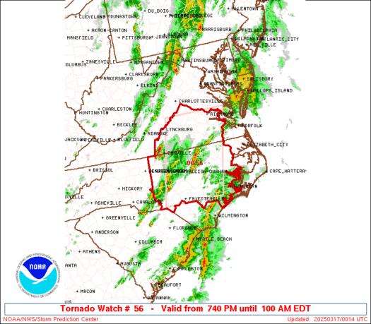
Tornado Watch Number 56
NWS Storm Prediction Center Norman OK
740 PM EDT Sun Mar 16 2025
The NWS Storm Prediction Center has issued a
* Tornado Watch for portions of
Central and Eastern North Carolina
Southern Virginia
* Effective this Sunday night and Monday morning from 740 PM
until 100 AM EDT.
* Primary threats include...
A couple tornadoes possible
Scattered damaging wind gusts to 70 mph possible
Isolated large hail events to 1.5 inches in diameter possible
SUMMARY...Scattered severe thunderstorms will move northeast across
the watch area this evening, with a risk for a couple tornadoes,
damaging gusts, and isolated large hail.
The tornado watch area is approximately along and 65 statute miles
east and west of a line from 30 miles west northwest of Richmond VA
to 20 miles east southeast of Fayetteville NC. For a complete
depiction of the watch see the associated watch outline update
(WOUS64 KWNS WOU6).
PRECAUTIONARY/PREPAREDNESS ACTIONS...
REMEMBER...A Tornado Watch means conditions are favorable for
tornadoes and severe thunderstorms in and close to the watch
area. Persons in these areas should be on the lookout for
threatening weather conditions and listen for later statements
and possible warnings.
&&
AVIATION...Tornadoes and a few severe thunderstorms with hail
surface and aloft to 1.5 inches. Extreme turbulence and surface wind
gusts to 60 knots. A few cumulonimbi with maximum tops to 450. Mean
storm motion vector 23035.
...Bunting
   SEL6

   URGENT - IMMEDIATE BROADCAST REQUESTED
   Tornado Watch Number 56
   NWS Storm Prediction Center Norman OK
   740 PM EDT Sun Mar 16 2025

   The NWS Storm Prediction Center has issued a

   * Tornado Watch for portions of
     Central and Eastern North Carolina
     Southern Virginia

   * Effective this Sunday night and Monday morning from 740 PM
     until 100 AM EDT.

   * Primary threats include...
     A couple tornadoes possible
     Scattered damaging wind gusts to 70 mph possible
     Isolated large hail events to 1.5 inches in diameter possible

   SUMMARY...Scattered severe thunderstorms will move northeast across
   the watch area this evening, with a risk for a couple tornadoes,
   damaging gusts, and isolated large hail.

   The tornado watch area is approximately along and 65 statute miles
   east and west of a line from 30 miles west northwest of Richmond VA
   to 20 miles east southeast of Fayetteville NC. For a complete
   depiction of the watch see the associated watch outline update
   (WOUS64 KWNS WOU6).

   PRECAUTIONARY/PREPAREDNESS ACTIONS...

   REMEMBER...A Tornado Watch means conditions are favorable for
   tornadoes and severe thunderstorms in and close to the watch
   area. Persons in these areas should be on the lookout for
   threatening weather conditions and listen for later statements
   and possible warnings.

   &&

   AVIATION...Tornadoes and a few severe thunderstorms with hail
   surface and aloft to 1.5 inches. Extreme turbulence and surface wind
   gusts to 60 knots. A few cumulonimbi with maximum tops to 450. Mean
   storm motion vector 23035.

   ...Bunting
Note:
The Aviation Watch (SAW) product is an approximation to the watch area.
The actual watch is depicted by the shaded areas.
   SAW6
   WW 56 TORNADO NC VA 162340Z - 170500Z
   AXIS..65 STATUTE MILES EAST AND WEST OF LINE..
   30WNW RIC/RICHMOND VA/ - 20ESE FAY/FAYETTEVILLE NC/
   ..AVIATION COORDS.. 55NM E/W /26WNW RIC - 46NW ILM/
   HAIL SURFACE AND ALOFT..1.5 INCHES. WIND GUSTS..60 KNOTS.
   MAX TOPS TO 450. MEAN STORM MOTION VECTOR 23035.

   LAT...LON 37667662 34847741 34847969 37667901

   THIS IS AN APPROXIMATION TO THE WATCH AREA.  FOR A
   COMPLETE DEPICTION OF THE WATCH SEE WOUS64 KWNS
   FOR WOU6.
Watch 56 Status Report Message has not been issued yet.
Probability of 1 or more strong (EF2-EF5) tornadoes
Low (20%)
Wind
Probability of 10 or more severe wind events
Mod (40%)
Probability of 1 or more wind events > 65 knots
Low (20%)
Hail
Probability of 10 or more severe hail events
Low (20%)
Probability of 1 or more hailstones > 2 inches
Low (10%)
Combined Severe Hail/Wind
Probability of 6 or more combined severe hail/wind events
Mod (60%)
For each watch, probabilities for particular events inside the watch
(listed above in each table) are determined by the issuing forecaster.
The “Low” category contains probability values ranging from less than 2%
to 20% (EF2-EF5 tornadoes), less than 5% to 20% (all other probabilities),
“Moderate” from 30% to 60%, and “High” from 70% to greater than 95%.
High values are bolded and lighter in color to provide awareness of
an increased threat for a particular event.