Note:
The expiration time in the watch graphic is amended if the watch is
replaced, cancelled or extended. Note: Click for Watch Status Reports.
SEL7
URGENT - IMMEDIATE BROADCAST REQUESTED
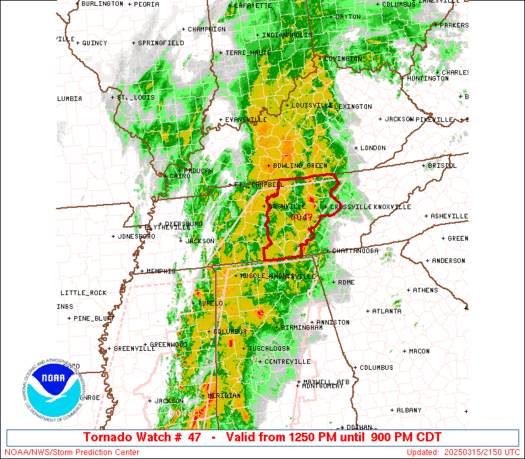
Tornado Watch Number 47
NWS Storm Prediction Center Norman OK
1250 PM CDT Sat Mar 15 2025
The NWS Storm Prediction Center has issued a
* Tornado Watch for portions of
Middle Tennessee
* Effective this Saturday afternoon and evening from 1250 PM
until 900 PM CDT.
* Primary threats include...
Several tornadoes and a couple intense tornadoes likely
Widespread damaging winds and isolated significant gusts to 75
mph likely
Scattered large hail and isolated very large hail events to 2
inches in diameter possible
SUMMARY...A line of thunderstorms will spread east-northeastward
across middle Tennessee this afternoon and evening. Widespread
damaging winds up to 60-75 mph are expected along with several
tornadoes as the environment becomes increasingly favorable for
severe thunderstorms. A couple strong to intense tornadoes also
appear posssible with any embedded supercells.
The tornado watch area is approximately along and 65 statute miles
east and west of a line from 65 miles east northeast of Nashville TN
to 85 miles south southwest of Nashville TN. For a complete
depiction of the watch see the associated watch outline update
(WOUS64 KWNS WOU7).
PRECAUTIONARY/PREPAREDNESS ACTIONS...
REMEMBER...A Tornado Watch means conditions are favorable for
tornadoes and severe thunderstorms in and close to the watch
area. Persons in these areas should be on the lookout for
threatening weather conditions and listen for later statements
and possible warnings.
&&
OTHER WATCH INFORMATION...CONTINUE...WW 44...WW 45...WW 46...
AVIATION...Tornadoes and a few severe thunderstorms with hail
surface and aloft to 2 inches. Extreme turbulence and surface wind
gusts to 65 knots. A few cumulonimbi with maximum tops to 500. Mean
storm motion vector 24040.
...Gleason
Note:
The Aviation Watch (SAW) product is an approximation to the watch area.
The actual watch is depicted by the shaded areas.
   SAW7
   WW 47 TORNADO TN 151750Z - 160200Z
   AXIS..65 STATUTE MILES EAST AND WEST OF LINE..
   65ENE BNA/NASHVILLE TN/ - 85SSW BNA/NASHVILLE TN/
   ..AVIATION COORDS.. 55NM E/W /49ESE BWG - 21NNE MSL/
   HAIL SURFACE AND ALOFT..2 INCHES. WIND GUSTS..65 KNOTS.
   MAX TOPS TO 500. MEAN STORM MOTION VECTOR 24040.

   LAT...LON 36488443 34998611 34998840 36488677

   THIS IS AN APPROXIMATION TO THE WATCH AREA.  FOR A
   COMPLETE DEPICTION OF THE WATCH SEE WOUS64 KWNS
   FOR WOU7.
Watch 47 Status Report Messages:
STATUS REPORT #4 ON WW 47

VALID 152150Z - 152240Z

SEVERE WEATHER THREAT CONTINUES RIGHT OF A LINE FROM 30 N HSV TO
50 SSE BNA TO 50 E BWG.

..LYONS..03/15/25

ATTN...WFO...OHX...HUN...

&&

STATUS REPORT FOR WT 47

SEVERE WEATHER THREAT CONTINUES FOR THE FOLLOWING AREAS

TNC003-015-027-031-035-041-049-051-061-087-103-127-133-137-141-
175-177-185-152240-

TN
.    TENNESSEE COUNTIES INCLUDED ARE

BEDFORD 	     CANNON		 CLAY
COFFEE		     CUMBERLAND 	 DE KALB
FENTRESS	     FRANKLIN		 GRUNDY
JACKSON 	     LINCOLN		 MOORE
OVERTON 	     PICKETT		 PUTNAM
VAN BUREN	     WARREN		 WHITE
$$


THE WATCH STATUS MESSAGE IS FOR GUIDANCE PURPOSES ONLY.  PLEASE
REFER TO WATCH COUNTY NOTIFICATION STATEMENTS FOR OFFICIAL
INFORMATION ON COUNTIES...INDEPENDENT CITIES AND MARINE ZONES
CLEARED FROM SEVERE THUNDERSTORM AND TORNADO WATCHES.
$$

STATUS REPORT #3 ON WW 47

VALID 152035Z - 152140Z

SEVERE WEATHER THREAT CONTINUES RIGHT OF A LINE FROM 25 NNW MSL
TO 20 SSE BNA TO 35 SSE BWG.

..GRAMS..03/15/25

ATTN...WFO...OHX...HUN...

&&

STATUS REPORT FOR WT 47

SEVERE WEATHER THREAT CONTINUES FOR THE FOLLOWING AREAS

TNC003-015-027-031-035-041-049-051-055-061-087-103-111-117-127-
133-137-141-149-159-169-175-177-185-189-152140-

TN
.    TENNESSEE COUNTIES INCLUDED ARE

BEDFORD 	     CANNON		 CLAY
COFFEE		     CUMBERLAND 	 DE KALB
FENTRESS	     FRANKLIN		 GILES
GRUNDY		     JACKSON		 LINCOLN
MACON		     MARSHALL		 MOORE
OVERTON 	     PICKETT		 PUTNAM
RUTHERFORD	     SMITH		 TROUSDALE
VAN BUREN	     WARREN		 WHITE
WILSON
$$


THE WATCH STATUS MESSAGE IS FOR GUIDANCE PURPOSES ONLY.  PLEASE
REFER TO WATCH COUNTY NOTIFICATION STATEMENTS FOR OFFICIAL
INFORMATION ON COUNTIES...INDEPENDENT CITIES AND MARINE ZONES
CLEARED FROM SEVERE THUNDERSTORM AND TORNADO WATCHES.
$$

STATUS REPORT #2 ON WW 47

VALID 151930Z - 152040Z

SEVERE WEATHER THREAT CONTINUES RIGHT OF A LINE FROM 25 NW MSL TO
25 N BNA.

FOR ADDITIONAL INFORMATION SEE MESOSCALE DISCUSSION 208.

..GRAMS..03/15/25

ATTN...WFO...OHX...HUN...

&&

STATUS REPORT FOR WT 47

SEVERE WEATHER THREAT CONTINUES FOR THE FOLLOWING AREAS

TNC003-015-027-031-035-037-041-049-051-055-061-081-087-099-101-
103-111-117-119-127-133-137-141-147-149-159-165-169-175-177-181-
185-187-189-152040-

TN
.    TENNESSEE COUNTIES INCLUDED ARE

BEDFORD 	     CANNON		 CLAY
COFFEE		     CUMBERLAND 	 DAVIDSON
DE KALB 	     FENTRESS		 FRANKLIN
GILES		     GRUNDY		 HICKMAN
JACKSON 	     LAWRENCE		 LEWIS
LINCOLN 	     MACON		 MARSHALL
MAURY		     MOORE		 OVERTON
PICKETT 	     PUTNAM		 ROBERTSON
RUTHERFORD	     SMITH		 SUMNER
TROUSDALE	     VAN BUREN		 WARREN
WAYNE		     WHITE		 WILLIAMSON
WILSON
$$


THE WATCH STATUS MESSAGE IS FOR GUIDANCE PURPOSES ONLY.  PLEASE
REFER TO WATCH COUNTY NOTIFICATION STATEMENTS FOR OFFICIAL
INFORMATION ON COUNTIES...INDEPENDENT CITIES AND MARINE ZONES
CLEARED FROM SEVERE THUNDERSTORM AND TORNADO WATCHES.
$$

STATUS REPORT #1 ON WW 47

VALID 151830Z - 151940Z

THE SEVERE WEATHER THREAT CONTINUES ACROSS THE ENTIRE WATCH AREA.

FOR ADDITIONAL INFORMATION SEE MESOSCALE DISCUSSION 203

..THORNTON..03/15/25

ATTN...WFO...OHX...HUN...

&&

STATUS REPORT FOR WT 47

SEVERE WEATHER THREAT CONTINUES FOR THE FOLLOWING AREAS

TNC003-015-021-027-031-035-037-041-043-049-051-055-061-081-087-
099-101-103-111-117-119-127-133-135-137-141-147-149-159-165-169-
175-177-181-185-187-189-151940-

TN
.    TENNESSEE COUNTIES INCLUDED ARE

BEDFORD 	     CANNON		 CHEATHAM
CLAY		     COFFEE		 CUMBERLAND
DAVIDSON	     DE KALB		 DICKSON
FENTRESS	     FRANKLIN		 GILES
GRUNDY		     HICKMAN		 JACKSON
LAWRENCE	     LEWIS		 LINCOLN
MACON		     MARSHALL		 MAURY
MOORE		     OVERTON		 PERRY
PICKETT 	     PUTNAM		 ROBERTSON
RUTHERFORD	     SMITH		 SUMNER
TROUSDALE	     VAN BUREN		 WARREN
WAYNE		     WHITE		 WILLIAMSON
WILSON
$$


THE WATCH STATUS MESSAGE IS FOR GUIDANCE PURPOSES ONLY.  PLEASE
REFER TO WATCH COUNTY NOTIFICATION STATEMENTS FOR OFFICIAL
INFORMATION ON COUNTIES...INDEPENDENT CITIES AND MARINE ZONES
CLEARED FROM SEVERE THUNDERSTORM AND TORNADO WATCHES.
$$
Probability of 1 or more strong (EF2-EF5) tornadoes
Mod (60%)
Wind
Probability of 10 or more severe wind events
High (90%)
Probability of 1 or more wind events > 65 knots
High (70%)
Hail
Probability of 10 or more severe hail events
Mod (50%)
Probability of 1 or more hailstones > 2 inches
Mod (30%)
Combined Severe Hail/Wind
Probability of 6 or more combined severe hail/wind events
High (>95%)
For each watch, probabilities for particular events inside the watch
(listed above in each table) are determined by the issuing forecaster.
The “Low” category contains probability values ranging from less than 2%
to 20% (EF2-EF5 tornadoes), less than 5% to 20% (all other probabilities),
“Moderate” from 30% to 60%, and “High” from 70% to greater than 95%.
High values are bolded and lighter in color to provide awareness of
an increased threat for a particular event.