Note:
The expiration time in the watch graphic is amended if the watch is
replaced, cancelled or extended. Note: Click for Watch Status Reports.
SEL6
URGENT - IMMEDIATE BROADCAST REQUESTED
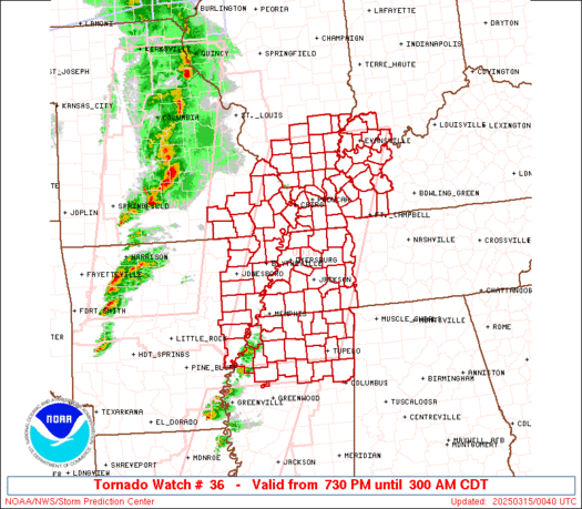
Tornado Watch Number 36
NWS Storm Prediction Center Norman OK
730 PM CDT Fri Mar 14 2025
The NWS Storm Prediction Center has issued a
* Tornado Watch for portions of
Northeast Arkansas
Southern Illinois
Far Southwest Indiana
Western Kentucky
Southeast Missouri
Northern Mississippi
Western Tennessee
* Effective this Friday night and Saturday morning from 730 PM
until 300 AM CDT.
...THIS IS A PARTICULARLY DANGEROUS SITUATION...
* Primary threats include...
Several tornadoes and a few intense tornadoes likely
Widespread damaging winds and scattered significant gusts to 80
mph likely
Scattered large hail and isolated very large hail events to 2.5
inches in diameter likely
SUMMARY...Severe thunderstorms are expected to develop across the
watch area over the next several hours. Environmental conditions are
very favorable for supercells capable of all severe hazards,
including very large hail (i.e. greater than 2" in diameter) and
strong (EF2+) tornadoes. If storms can remain discrete, potential
exists for a few long-track tornadoes.
The tornado watch area is approximately along and 75 statute miles
east and west of a line from 40 miles west northwest of Evansville
IN to 25 miles southwest of Oxford MS. For a complete depiction of
the watch see the associated watch outline update (WOUS64 KWNS
WOU6).
PRECAUTIONARY/PREPAREDNESS ACTIONS...
REMEMBER...A Tornado Watch means conditions are favorable for
tornadoes and severe thunderstorms in and close to the watch
area. Persons in these areas should be on the lookout for
threatening weather conditions and listen for later statements
and possible warnings.
&&
OTHER WATCH INFORMATION...CONTINUE...WW 31...WW 32...WW 33...WW
34...WW 35...
AVIATION...Tornadoes and a few severe thunderstorms with hail
surface and aloft to 2.5 inches. Extreme turbulence and surface wind
gusts to 70 knots. A few cumulonimbi with maximum tops to 500. Mean
storm motion vector 24035.
...Mosier
   SEL6

   URGENT - IMMEDIATE BROADCAST REQUESTED
   Tornado Watch Number 36
   NWS Storm Prediction Center Norman OK
   730 PM CDT Fri Mar 14 2025

   The NWS Storm Prediction Center has issued a

   * Tornado Watch for portions of
     Northeast Arkansas
     Southern Illinois
     Far Southwest Indiana
     Western Kentucky
     Southeast Missouri
     Northern Mississippi
     Western Tennessee

   * Effective this Friday night and Saturday morning from 730 PM
     until 300 AM CDT.

   ...THIS IS A PARTICULARLY DANGEROUS SITUATION...

   * Primary threats include...
     Several tornadoes and a few intense tornadoes likely
     Widespread damaging winds and scattered significant gusts to 80
       mph likely
     Scattered large hail and isolated very large hail events to 2.5
       inches in diameter likely

   SUMMARY...Severe thunderstorms are expected to develop across the
   watch area over the next several hours. Environmental conditions are
   very favorable for supercells capable of all severe hazards,
   including very large hail (i.e. greater than 2" in diameter) and
   strong (EF2+) tornadoes. If storms can remain discrete, potential
   exists for a few long-track tornadoes.

   The tornado watch area is approximately along and 75 statute miles
   east and west of a line from 40 miles west northwest of Evansville
   IN to 25 miles southwest of Oxford MS. For a complete depiction of
   the watch see the associated watch outline update (WOUS64 KWNS
   WOU6).

   PRECAUTIONARY/PREPAREDNESS ACTIONS...

   REMEMBER...A Tornado Watch means conditions are favorable for
   tornadoes and severe thunderstorms in and close to the watch
   area. Persons in these areas should be on the lookout for
   threatening weather conditions and listen for later statements
   and possible warnings.

   &&

   OTHER WATCH INFORMATION...CONTINUE...WW 31...WW 32...WW 33...WW
   34...WW 35...

   AVIATION...Tornadoes and a few severe thunderstorms with hail
   surface and aloft to 2.5 inches. Extreme turbulence and surface wind
   gusts to 70 knots. A few cumulonimbi with maximum tops to 500. Mean
   storm motion vector 24035.

   ...Mosier
Note:
The Aviation Watch (SAW) product is an approximation to the watch area.
The actual watch is depicted by the shaded areas.
   SAW6
   WW 36 TORNADO AR IL IN KY MO MS TN 150030Z - 150800Z
   AXIS..75 STATUTE MILES EAST AND WEST OF LINE..
   40WNW EVV/EVANSVILLE IN/ - 25SW UOX/OXFORD MS/
   ..AVIATION COORDS.. 65NM E/W /29NW PXV - 46NNE SQS/
   HAIL SURFACE AND ALOFT..2.5 INCHES. WIND GUSTS..70 KNOTS.
   MAX TOPS TO 500. MEAN STORM MOTION VECTOR 24035.

   LAT...LON 38248683 34128853 34129115 38248959

   THIS IS AN APPROXIMATION TO THE WATCH AREA.  FOR A
   COMPLETE DEPICTION OF THE WATCH SEE WOUS64 KWNS
   FOR WOU6.
Watch 36 Status Report Messages:
STATUS REPORT #3 ON WW 36

VALID 150620Z - 150740Z

SEVERE WEATHER THREAT CONTINUES RIGHT OF A LINE FROM 15 WSW ARG
TO 5 N CGI TO 15 NE MVN TO 15 SSW MTO.

FOR ADDITIONAL INFORMATION SEE MESOSCALE DISCUSSION 188

..MOORE..03/15/25

ATTN...WFO...MEG...PAH...

&&

STATUS REPORT FOR WT 36

SEVERE WEATHER THREAT CONTINUES FOR THE FOLLOWING AREAS

ARC021-031-035-037-055-077-093-107-111-123-150740-

AR
.    ARKANSAS COUNTIES INCLUDED ARE

CLAY		     CRAIGHEAD		 CRITTENDEN
CROSS		     GREENE		 LEE
MISSISSIPPI	     PHILLIPS		 POINSETT
ST. FRANCIS
$$


ILC003-047-055-059-065-069-087-127-151-153-165-181-185-191-193-
199-150740-

IL
.    ILLINOIS COUNTIES INCLUDED ARE

ALEXANDER	     EDWARDS		 FRANKLIN
GALLATIN	     HAMILTON		 HARDIN
JOHNSON 	     MASSAC		 POPE
PULASKI 	     SALINE		 UNION
WABASH		     WAYNE		 WHITE
WILLIAMSON
$$


INC051-125-129-147-163-173-150740-

IN
.    INDIANA COUNTIES INCLUDED ARE

GIBSON		     PIKE		 POSEY
SPENCER 	     VANDERBURGH	 WARRICK
$$


KYC007-033-035-039-047-055-059-075-083-101-105-107-139-143-145-
149-157-177-219-221-225-233-150740-

KY
.    KENTUCKY COUNTIES INCLUDED ARE

BALLARD 	     CALDWELL		 CALLOWAY
CARLISLE	     CHRISTIAN		 CRITTENDEN
DAVIESS 	     FULTON		 GRAVES
HENDERSON	     HICKMAN		 HOPKINS
LIVINGSTON	     LYON		 MCCRACKEN
MCLEAN		     MARSHALL		 MUHLENBERG
TODD		     TRIGG		 UNION
WEBSTER
$$


MSC003-009-013-017-027-033-057-071-081-093-095-107-115-117-119-
135-137-139-141-143-145-161-150740-

MS
.    MISSISSIPPI COUNTIES INCLUDED ARE

ALCORN		     BENTON		 CALHOUN
CHICKASAW	     COAHOMA		 DESOTO
ITAWAMBA	     LAFAYETTE		 LEE
MARSHALL	     MONROE		 PANOLA
PONTOTOC	     PRENTISS		 QUITMAN
TALLAHATCHIE	     TATE		 TIPPAH
TISHOMINGO	     TUNICA		 UNION
YALOBUSHA
$$


MOC069-133-143-155-201-207-150740-

MO
.    MISSOURI COUNTIES INCLUDED ARE

DUNKLIN 	     MISSISSIPPI	 NEW MADRID
PEMISCOT	     SCOTT		 STODDARD
$$


TNC005-017-023-033-039-045-047-053-069-071-075-077-079-095-097-
109-113-131-157-167-183-150740-

TN
.    TENNESSEE COUNTIES INCLUDED ARE

BENTON		     CARROLL		 CHESTER
CROCKETT	     DECATUR		 DYER
FAYETTE 	     GIBSON		 HARDEMAN
HARDIN		     HAYWOOD		 HENDERSON
HENRY		     LAKE		 LAUDERDALE
MCNAIRY 	     MADISON		 OBION
SHELBY		     TIPTON		 WEAKLEY
$$


THE WATCH STATUS MESSAGE IS FOR GUIDANCE PURPOSES ONLY.  PLEASE
REFER TO WATCH COUNTY NOTIFICATION STATEMENTS FOR OFFICIAL
INFORMATION ON COUNTIES...INDEPENDENT CITIES AND MARINE ZONES
CLEARED FROM SEVERE THUNDERSTORM AND TORNADO WATCHES.
$$

STATUS REPORT #2 ON WW 36

VALID 150540Z - 150640Z

SEVERE WEATHER THREAT CONTINUES RIGHT OF A LINE FROM 15 E POF TO
15 WSW MVN.

..GOSS..03/15/25

ATTN...WFO...MEG...PAH...

&&

STATUS REPORT FOR WT 36

SEVERE WEATHER THREAT CONTINUES FOR THE FOLLOWING AREAS

ARC021-031-035-037-055-077-093-107-111-123-150640-

AR
.    ARKANSAS COUNTIES INCLUDED ARE

CLAY		     CRAIGHEAD		 CRITTENDEN
CROSS		     GREENE		 LEE
MISSISSIPPI	     PHILLIPS		 POINSETT
ST. FRANCIS
$$


ILC003-047-055-059-065-069-077-081-087-127-151-153-165-181-185-
191-193-199-150640-

IL
.    ILLINOIS COUNTIES INCLUDED ARE

ALEXANDER	     EDWARDS		 FRANKLIN
GALLATIN	     HAMILTON		 HARDIN
JACKSON 	     JEFFERSON		 JOHNSON
MASSAC		     POPE		 PULASKI
SALINE		     UNION		 WABASH
WAYNE		     WHITE		 WILLIAMSON
$$


INC051-125-129-147-163-173-150640-

IN
.    INDIANA COUNTIES INCLUDED ARE

GIBSON		     PIKE		 POSEY
SPENCER 	     VANDERBURGH	 WARRICK
$$


KYC007-033-035-039-047-055-059-075-083-101-105-107-139-143-145-
149-157-177-219-221-225-233-150640-

KY
.    KENTUCKY COUNTIES INCLUDED ARE

BALLARD 	     CALDWELL		 CALLOWAY
CARLISLE	     CHRISTIAN		 CRITTENDEN
DAVIESS 	     FULTON		 GRAVES
HENDERSON	     HICKMAN		 HOPKINS
LIVINGSTON	     LYON		 MCCRACKEN
MCLEAN		     MARSHALL		 MUHLENBERG
TODD		     TRIGG		 UNION
WEBSTER
$$


MSC003-009-013-017-027-033-057-071-081-093-095-107-115-117-119-
135-137-139-141-143-145-161-150640-

MS
.    MISSISSIPPI COUNTIES INCLUDED ARE

ALCORN		     BENTON		 CALHOUN
CHICKASAW	     COAHOMA		 DESOTO
ITAWAMBA	     LAFAYETTE		 LEE
MARSHALL	     MONROE		 PANOLA
PONTOTOC	     PRENTISS		 QUITMAN
TALLAHATCHIE	     TATE		 TIPPAH
TISHOMINGO	     TUNICA		 UNION
YALOBUSHA
$$


MOC031-069-133-143-155-201-207-150640-

MO
.    MISSOURI COUNTIES INCLUDED ARE

CAPE GIRARDEAU	     DUNKLIN		 MISSISSIPPI
NEW MADRID	     PEMISCOT		 SCOTT
STODDARD
$$


TNC005-017-023-033-039-045-047-053-069-071-075-077-079-095-097-
109-113-131-157-167-183-150640-

TN
.    TENNESSEE COUNTIES INCLUDED ARE

BENTON		     CARROLL		 CHESTER
CROCKETT	     DECATUR		 DYER
FAYETTE 	     GIBSON		 HARDEMAN
HARDIN		     HAYWOOD		 HENDERSON
HENRY		     LAKE		 LAUDERDALE
MCNAIRY 	     MADISON		 OBION
SHELBY		     TIPTON		 WEAKLEY
$$


THE WATCH STATUS MESSAGE IS FOR GUIDANCE PURPOSES ONLY.  PLEASE
REFER TO WATCH COUNTY NOTIFICATION STATEMENTS FOR OFFICIAL
INFORMATION ON COUNTIES...INDEPENDENT CITIES AND MARINE ZONES
CLEARED FROM SEVERE THUNDERSTORM AND TORNADO WATCHES.
$$

STATUS REPORT #1 ON WW 36

VALID 150240Z - 150340Z

THE SEVERE WEATHER THREAT CONTINUES ACROSS THE ENTIRE WATCH AREA.

..MOORE..03/15/25

ATTN...WFO...MEG...PAH...

&&

STATUS REPORT FOR WT 36

SEVERE WEATHER THREAT CONTINUES FOR THE FOLLOWING AREAS

ARC021-031-035-037-055-077-093-107-111-123-150340-

AR
.    ARKANSAS COUNTIES INCLUDED ARE

CLAY		     CRAIGHEAD		 CRITTENDEN
CROSS		     GREENE		 LEE
MISSISSIPPI	     PHILLIPS		 POINSETT
ST. FRANCIS
$$


ILC003-047-055-059-065-069-077-081-087-127-145-151-153-165-181-
185-191-193-199-150340-

IL
.    ILLINOIS COUNTIES INCLUDED ARE

ALEXANDER	     EDWARDS		 FRANKLIN
GALLATIN	     HAMILTON		 HARDIN
JACKSON 	     JEFFERSON		 JOHNSON
MASSAC		     PERRY		 POPE
PULASKI 	     SALINE		 UNION
WABASH		     WAYNE		 WHITE
WILLIAMSON
$$


INC051-125-129-147-163-173-150340-

IN
.    INDIANA COUNTIES INCLUDED ARE

GIBSON		     PIKE		 POSEY
SPENCER 	     VANDERBURGH	 WARRICK
$$


KYC007-033-035-039-047-055-059-075-083-101-105-107-139-143-145-
149-157-177-219-221-225-233-150340-

KY
.    KENTUCKY COUNTIES INCLUDED ARE

BALLARD 	     CALDWELL		 CALLOWAY
CARLISLE	     CHRISTIAN		 CRITTENDEN
DAVIESS 	     FULTON		 GRAVES
HENDERSON	     HICKMAN		 HOPKINS
LIVINGSTON	     LYON		 MCCRACKEN
MCLEAN		     MARSHALL		 MUHLENBERG
TODD		     TRIGG		 UNION
WEBSTER
$$


MSC003-009-013-017-027-033-057-071-081-093-095-107-115-117-119-
135-137-139-141-143-145-161-150340-

MS
.    MISSISSIPPI COUNTIES INCLUDED ARE

ALCORN		     BENTON		 CALHOUN
CHICKASAW	     COAHOMA		 DESOTO
ITAWAMBA	     LAFAYETTE		 LEE
MARSHALL	     MONROE		 PANOLA
PONTOTOC	     PRENTISS		 QUITMAN
TALLAHATCHIE	     TATE		 TIPPAH
TISHOMINGO	     TUNICA		 UNION
YALOBUSHA
$$


MOC017-023-031-035-069-133-143-155-157-181-201-207-223-150340-

MO
.    MISSOURI COUNTIES INCLUDED ARE

BOLLINGER	     BUTLER		 CAPE GIRARDEAU
CARTER		     DUNKLIN		 MISSISSIPPI
NEW MADRID	     PEMISCOT		 PERRY
RIPLEY		     SCOTT		 STODDARD
WAYNE
$$


TNC005-017-023-033-039-045-047-053-069-071-075-077-079-095-097-
109-113-131-157-167-183-150340-

TN
.    TENNESSEE COUNTIES INCLUDED ARE

BENTON		     CARROLL		 CHESTER
CROCKETT	     DECATUR		 DYER
FAYETTE 	     GIBSON		 HARDEMAN
HARDIN		     HAYWOOD		 HENDERSON
HENRY		     LAKE		 LAUDERDALE
MCNAIRY 	     MADISON		 OBION
SHELBY		     TIPTON		 WEAKLEY
$$


THE WATCH STATUS MESSAGE IS FOR GUIDANCE PURPOSES ONLY.  PLEASE
REFER TO WATCH COUNTY NOTIFICATION STATEMENTS FOR OFFICIAL
INFORMATION ON COUNTIES...INDEPENDENT CITIES AND MARINE ZONES
CLEARED FROM SEVERE THUNDERSTORM AND TORNADO WATCHES.
$$
Probability of 1 or more strong (EF2-EF5) tornadoes
High (80%)
Wind
Probability of 10 or more severe wind events
High (80%)
Probability of 1 or more wind events > 65 knots
High (80%)
Hail
Probability of 10 or more severe hail events
Mod (60%)
Probability of 1 or more hailstones > 2 inches
Mod (60%)
Combined Severe Hail/Wind
Probability of 6 or more combined severe hail/wind events
High (>95%)
For each watch, probabilities for particular events inside the watch
(listed above in each table) are determined by the issuing forecaster.
The “Low” category contains probability values ranging from less than 2%
to 20% (EF2-EF5 tornadoes), less than 5% to 20% (all other probabilities),
“Moderate” from 30% to 60%, and “High” from 70% to greater than 95%.
High values are bolded and lighter in color to provide awareness of
an increased threat for a particular event.