
150 million brace for severe weather outbreak as Friday begins multiday threat for long-track tornadoes
3 min read
An outbreak of severe storms is likely Friday afternoon and potentially into the overnight hours as a powerful storm system intensifies across the central U.S. All hazards are possible, including swaths of intense winds and tornadoes.
Fast Facts:
- An outbreak of severe storms is likely Friday afternoon and potentially into the overnight hours as a powerful storm system intensifies across the central U.S.
- These storms could bring significant tornadoes (EF-3+) as even more intense storms form Saturday evening in the South.
- Final days of storms to slam East Coast on Sunday from Florida to Northeast.
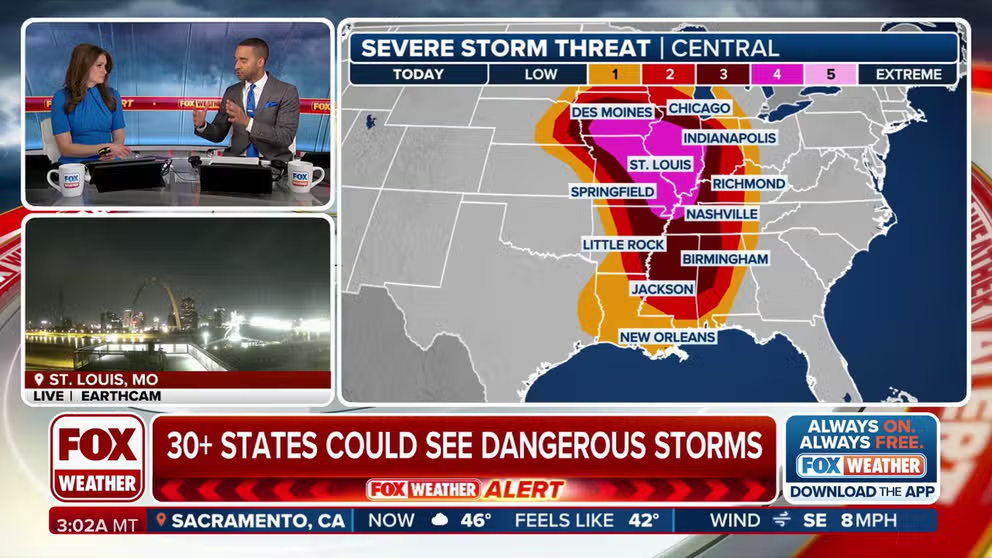
A widespread and dangerous severe weather outbreak is expected to develop Friday and into the weekend as it unleashes its fury across the central and eastern U.S., impacting over 150 million people.
The FOX Forecast Center said that multiple days of potent thunderstorms could bring destructive winds, large hail, and significant tornado activity (EF-3 or higher).
The main action on Friday will come in the form of a powerful squall line of storms which is expected to develop during the afternoon across Missouri and Iowa and charge east through the Mississippi Valley, the FOX Forecast Center said.
DOWNLOAD THE FREE FOX WEATHER APP

(FOX Weather)
The highest risk for tornadoes is over 750 miles from Davenport, Iowa, to Jackson, Mississippi. The overall tornado threat is over 1,000 miles long. The states with the most concern look to be centered in the mid-Mississippi Valley, including cities like St. Louis, Memphis, Paducah and Little Rock.
Tornadoes, several of which could be strong, widespread damaging winds with gusts from 70 to 90 mph, and scattered large hail up to baseball-size will be possible, according to NOAA’s Storm Prediction Center.
Multiple intense, long-tracked tornadoes possible Saturday
On Saturday, the powerful storm system will continue tracking east as a tornado outbreak is possible across the central Gulf Coast states and Deep South into the Tennessee Valley.
WATCH VS. WARNING: HERE ARE THE DIFFERENCES BETWEEN THESE WEATHER TERMS THAT COULD SAVE YOUR LIFE

(FOX Weather)
The storms will develop along the Mississippi River and quickly move east from midday to the afternoon, the FOX Forecast Center said. The line of supercells is then expected to swing through central and southern Mississippi into northern Alabama, central and east Tennessee and north Georgia.
Cities like New Orleans, Louisiana, and Birmingham, Alabama, are under a Level 4 out of 5 risk, indicating a high likelihood of supercell thunderstorms capable of producing tornadoes and damaging winds.
Final days of storms likely to slam East Coast on Sunday
By Sunday, the storm will have traversed across the entire U.S. with its eye now on the East Coast, including the I-95 corridor. The threat of tornadoes will be confined from the Virginia coast south into the Carolinas. Damaging wind gusts and large hail will be the main threats.
STAY OR GO? TRUSTING YOUR GUT CAN BE LIFESAVING WHEN MULTIPLE WEATHER WARNINGS ARE ISSUED

(FOX Weather)
Like on Friday and Saturday, plenty of wind shear will be present, allowing any singular storm to rotate and produce a tornado, the FOX Forecast Center said.
North of the Delmarva into the Northeast, severe storms will also be possible.
https://images.foxweather.com/static.foxweather.com/www.foxweather.com/content/uploads/2025/03/1024/512/adobestock_262447970.jpeg?ve=1&tl=1
2025-03-14 10:45:28


