
Blizzards, ferocious winds to emerge in Plains as winter storm fuels fire threats
4 min read
The FOX Forecast Center is tracking a powerful storm set to emerge from the Rockies and rapidly strengthen over the Plains by Thursday.
Fast Facts:
- This powerful storm boasts an expansive wind field and potentially record-low March pressure in the Plains.
- Despite a lack of extreme cold limiting snowfall, blowing snow will create blizzard conditions and whiteouts that will make travel impossible in some areas.
- Midwest airport hubs in cities like Chicago, Milwaukee and Minneapolis are likely to experience major delays.
- Destructive winds are likely to knock out power to hundreds of thousands.
Residents across the northern Plains and parts of the Midwest are preparing for a powerful winter storm that will bring strong winds, blowing snow and plummeting temperatures, potentially creating blizzard conditions and hazardous travel.
The FOX Forecast Center is actively tracking the significant cross-country weather system. Originating as an atmospheric river drenching California, this system is projected to rapidly intensify as it emerges from the Rockies on Thursday.

(FOX Weather)
This strengthening storm poses a multiday severe weather threat for the central and eastern U.S. Simultaneously, it is generating urgent winter weather warnings for the Upper Midwest and High Plains and escalating fire danger alerts in the Southwest.
DANGEROUS SEVERE WEATHER OUTBREAK COULD UNLEASH HURRICANE-FORCE WIND GUSTS, STRONG TORNADOES
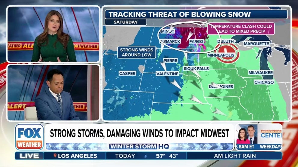
Blizzard conditions likely as wind gusts could reach 60-75 mph
Blizzard conditions are once again a possibility, though this time, the heaviest snow is expected farther north, the FOX Forecast Center said. The Dakotas, Montana, Wyoming and parts of Minnesota will be most at risk.

(FOX Weather)
However, like last week, snow totals could be limited due to a lack of deep cold air and strong southerly flow. The very narrow band of heavy snow that does develop could still create impossible travel conditions with high winds and whiteout conditions.
DOWNLOAD THE FREE FOX WEATHER APP

(FOX Weather)
Similar to last week, this system could challenge low-pressure records for parts of the Plains, plunging from the mid-990s millibars to the lower to mid-970s millibars in a short time, the FOX Forecast Center said. If the storm undergoes this rapid intensification, it will generate a massive wind response across much of the central U.S.

(FOX Weather)
“Because the pressure is so low in response to that pressure change, the winds are going to be nuts, especially on the backside,” FOX Weather Meteorologist Britta Merwin said. “Strong enough not only to take out power but the visibility concerns.”
Wind gusts could reach 60-75 mph, Merwin added, which could lead to blizzard or near-blizzard conditions.
HERE’S WHY ‘BLIZZARD ALLEY’ IS IN THE NORTHERN PLAINS

(FOX Weather)
Travel conditions are expected to deteriorate rapidly, with a moderate risk of blowing snow forecast not just on Friday, but into Saturday and Sunday as well. Interstate highways such as I-90 and I-29 are particularly vulnerable and could experience significant disruptions.
“That is going to have an impact for many people all the way from North Dakota clear down into portions of Nebraska and Iowa,” FOX Weather Meteorologist Craig Herrera said.
While the immediate snowfall may not be substantial, the real threat comes from the intense cold air following the storm’s passage.
Temperatures are expected to drop into the 30s and 40s on Friday, with further declines into the teens by Saturday night. Near-freezing temperatures are expected in cities like Grand Forks, North Dakota, and Sioux Falls, South Dakota.

(FOX Weather)
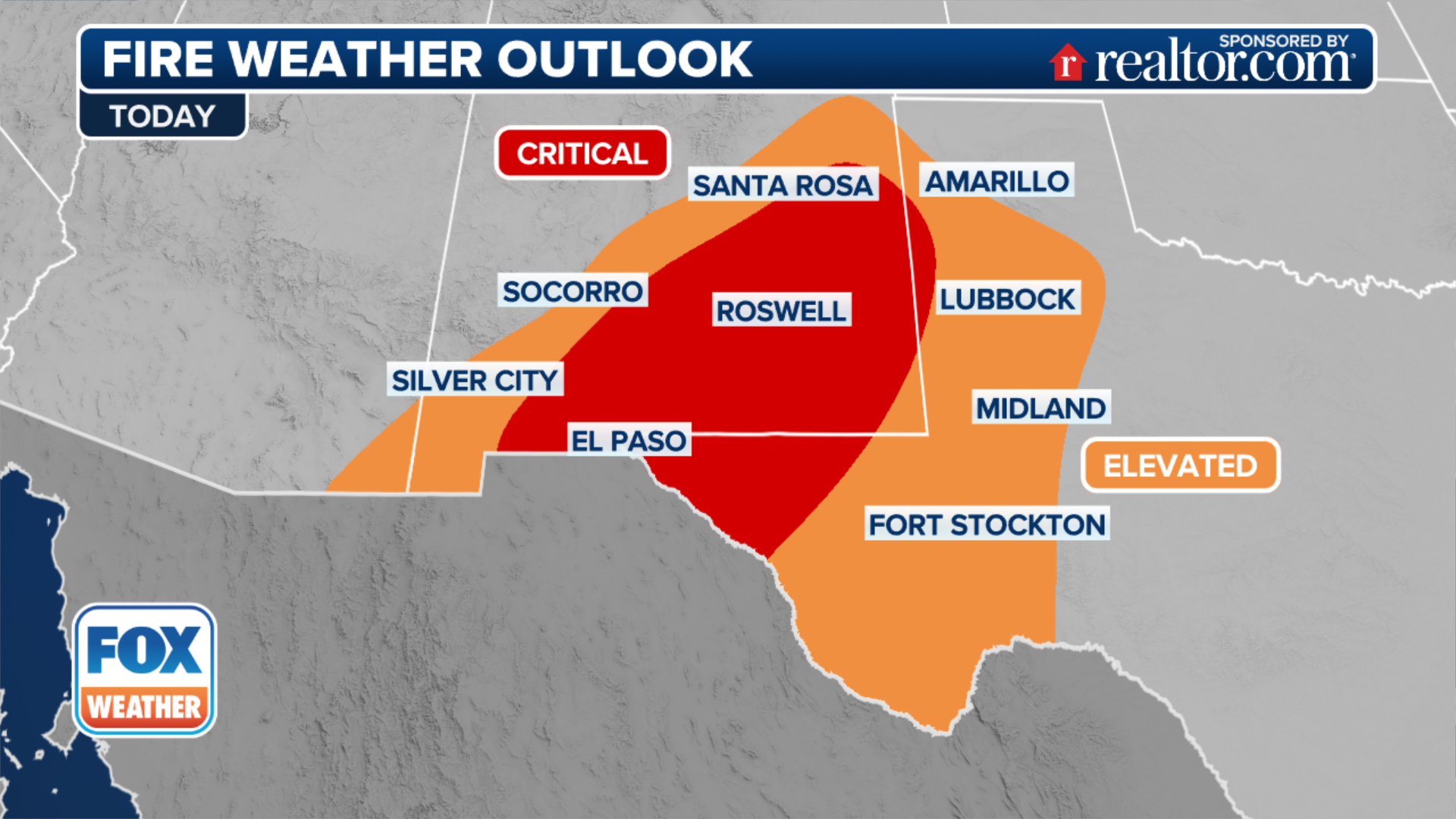
21 million face dangerous fire weather conditions on Friday
A dangerous fire-weather pattern is setting up across the southern Plains, with multiple rounds of dry, windy conditions expected.

(FOX Weather)
Friday appears to be the most dangerous day, as a powerful storm system and an intense 100-plus-mph jet stream move into the southern Plains, the FOX Forecast Center said.
As a series of storm systems move across the southern Rockies and High Plains, more than 21 million Americans will be under critical or extreme fire weather conditions.
(FOX Weather)
Another disturbance will likely move into the southern High Plains this weekend, causing the fire threat to continue. Given the ongoing dry and windy conditions, fire concerns are unlikely to end anytime soon, the FOX Forecast Center warned.
Be sure to download the free FOX Weather app and enable notifications to be alerted to changes in the forecast.
https://images.foxweather.com/static.foxweather.com/www.foxweather.com/content/uploads/2022/10/1024/512/GettyImages-161132711.jpg?ve=1&tl=1
2025-03-13 11:42:48


