
Storm Prediction Center Tornado Watch 10
3 min read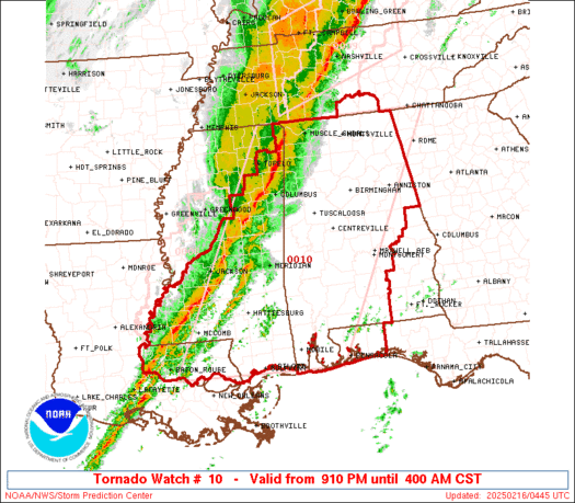

Note:
The expiration time in the watch graphic is amended if the watch is
replaced, cancelled or extended.
Note: Click for Watch Status Reports.
   SEL0

   URGENT - IMMEDIATE BROADCAST REQUESTED
   Tornado Watch Number 10
   NWS Storm Prediction Center Norman OK
   910 PM CST Sat Feb 15 2025

   The NWS Storm Prediction Center has issued a

   * Tornado Watch for portions of
     Much of Alabama
     Western Florida Panhandle
     Southeast Louisiana
     Central and Southern Mississippi
     Southern Middle Tennessee
     Coastal Waters

   * Effective this Saturday night and Sunday morning from 910 PM
     until 400 AM CST.

   * Primary threats include...
     A few tornadoes likely with a couple intense tornadoes possible
     Widespread damaging wind gusts to 70 mph likely
     Isolated large hail events to 1.5 inches in diameter possible

   SUMMARY...A fast-moving line of thunderstorms will overspread the
   watch area through the early morning hours.  Very strong winds aloft
   ahead of the line will pose a risk of damaging wind gusts and
   embedded tornadoes.

   The tornado watch area is approximately along and 110 statute miles
   east and west of a line from 10 miles southwest of Gulfport MS to 25
   miles north of Huntsville AL. For a complete depiction of the watch
   see the associated watch outline update (WOUS64 KWNS WOU0).

   PRECAUTIONARY/PREPAREDNESS ACTIONS...

   REMEMBER...A Tornado Watch means conditions are favorable for
   tornadoes and severe thunderstorms in and close to the watch
   area. Persons in these areas should be on the lookout for
   threatening weather conditions and listen for later statements
   and possible warnings.

   &&

   OTHER WATCH INFORMATION...CONTINUE...WW 8...WW 9...

   AVIATION...Tornadoes and a few severe thunderstorms with hail
   surface and aloft to 1.5 inches. Extreme turbulence and surface wind
   gusts to 60 knots. A few cumulonimbi with maximum tops to 450. Mean
   storm motion vector 27035.

   ...Hart

2025-02-16 03:10:03
