More Santa Ana winds forecast for Los Angeles as wildfires continue to burn
4 min read
Additional waves of strong and potentially damaging offshore Santa Ana winds are forecast over the weekend and into next week as the overall weather pattern that helped spread massive wildfires shows no signs of changing soon.
LOS ANGELES — Fresh off destructive wind and firestorms that have left at least five people dead and neighborhoods in ruins, the forecast remains daunting for Southern California, with additional damaging Santa Ana wind threats and critical fire weather danger continuing at times over the next several days.
While winds are not expected to reach the extreme levels seen during Tuesday night’s storm that registered widespread gusts from 80-100 mph, potentially damaging winds remain in the forecast into next week as the weather pattern features renewed offshore wind threats.
High Wind Warnings and Wind Advisories stretch across a wide swath of Southern California.

(FOX Weather)
Meanwhile, Fire Weather Warnings remain in effect for the greater Los Angeles area, including where the massive Palisades and Eaton wildfires continue to burn, into at least Friday evening due to strong winds and bone-dry humidity levels.
Northeast wind gusts are forecast to reach 40 mph through Thursday evening around the Los Angeles metro area and surrounding hills, then increase to 50-mph gusts Thursday night into Friday as another moderate to locally strong Santa Ana wind event hits. In addition, relative humidity levels will remain between 10% and 20% as the offshore winds hold the moist, ocean breezes at bay.

(FOX Weather)
“The wind component will still be offshore, meaning compressional heating as it goes down (the mountainsides) and it dries out,” said FOX Weather Meteorologist Bob Van Dillen.
Those conditions will continue to make it difficult to contain current wildfires, and allow any new fires to spread rapidly, as hundreds of thousands of residents have already seen firsthand this week.
A brief break in the dry offshore winds is expected later Friday through late Saturday, giving firefighters a welcome reprieve. But the Santa Ana winds loom once again Saturday night into Sunday with a return of strong gusts and extremely dry air.
“There is a decent chance of critical fire weather conditions redeveloping during this period,” National Weather Service forecasters in Los Angeles wrote in their Thursday morning forecast discussion.

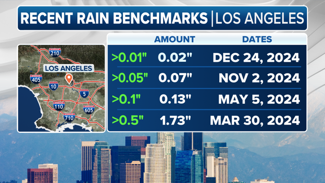
Los Angeles rainfall deficit.
(FOX Weather)
Another potentially dangerous round of Santa Ana winds next week
The Santa Ana winds are expected to taper off later Sunday, but forecasters are keeping a wary eye on the forecast for the middle of next week. Another area of cold, dense air brings high pressure in the Great Basin while another strong area of low pressure swings off the Southern California shore, signaling perhaps yet another potentially strong and damaging Santa Ana wind event starting Tuesday night and lingering through Wednesday.
FOX Weather’s Robert Ray recorded this video of the aftermath of the Palisades Fire that ripped through parts of the Los Angeles metro area.
“This would be concerning with likely no rain expected and the Tuesday night-Wednesday time period being the fourth offshore event in the stretch,” NWS Los Angeles forecasters wrote.
They added that conditions could become exacerbated by the lack of significant rain since last spring and the previous damage from wildfires.
“Residents are urged to stay tuned to the latest information and remain vigilant in steps to protect your life and property,” the NWS forecasters wrote.
https://images.foxweather.com/static.foxweather.com/www.foxweather.com/content/uploads/2025/01/1024/512/gettyimages-2193144336.jpg?ve=1&tl=1
2025-01-09 21:35:10


