Snow from winter storms to wreak havoc for millions as Christmas travel underway
6 min read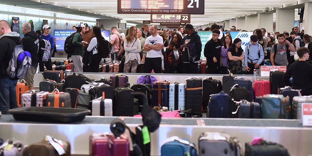
A significant warm-up will overtake the country during the holiday week with many cities seeing temperatures that resemble October-like levels.
NEW YORK – Millions of Americans are gearing up for Christmas travel, but inclement weather could dampen their festive plans.
While no major storms are forecast to disrupt holiday travel entirely, rounds of rain and winter weather are expected to slow things down, especially in the eastern U.S. With nearly 120 million people expected to travel this year – a record number of people for the Christmas period, according to AAA – it’s crucial to plan ahead and be flexible. Travelers should be prepared for potential delays on roads and at major airports.
A winter storm has left I-80 near Snow Shoe, Pennsylvania, blanketed in snow and ice, creating hazardous driving conditions.
Snow and ice led to a ground stop being issued at Chicago O’Hare International Airport on Friday morning, which put a pause on departures and arrivals at the busy travel hub.
Later in the morning, ground stops were issued in Boston and all three airports in the New York City area due to light snow, ice and heavy volumes. Nationwide flight delays totaled over 11,000 on Friday evening.
MOST WEATHER-DELAYED AIRPORTS DURING HOLIDAYS

(FOX Weather)
Unwrapping your Christmas Day forecast
The FOX Forecast Center is tracking everything naughty and nice as we enter Christmas week Monday, but how is the forecast looking for Santa’s track across the Lower 48 on Christmas Eve, and what can you expect when opening gifts on Christmas Day?
The FOX Forecast Center is monitoring who could potentially see a white Christmas this year as the countdown begins to December 25. The picture is becoming clearer, and we’re getting a better idea for who will see snow on the ground come Christmas morning.
Areas seeing some naughty weather Tuesday and Wednesday include the West as relentless rounds of rain and snow pummel states from Washington to California. This could make holiday travel tricky for many, especially while hitting the roads in the higher terrain.
Places seeing a nicer forecast for the big day are most of the central and eastern U.S. While some light rain and snow looks possible for areas such as Atlanta and Chicago on Christmas Day, any last-minute travel should not be majorly impacted. The quieter weather should allow for a more smooth travel day Wednesday.
CHRISTMAS TRAVEL TRACKER: LIVE MAPS, AIRPORT STATUS, FLIGHT DELAYS, FORECAST AND MORE

(FOX Weather)
Rounds of rain, snow to smack West Coast
The FOX Forecast Center is tracking a series of storms moving into the West and Northwest for the start of the weekend. While generally, these will be weak to moderate events, the prolonged period of windy and generally unsettled conditions will remain into the holiday week.
The flooding risk looks to remain low into the start of the weekend, but that changes by Monday.
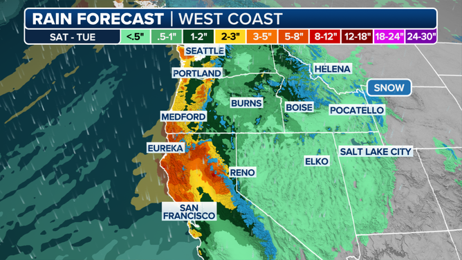
A look at the rain forecast along the West Coast through Tuesday.
(FOX Weather)
For portions of the West Coast from San Francisco to Seattle, moderate to even heavy rain could result in a low-end risk for flash flooding, starting next week. Through Tuesday, portions of Northern California and coastal Oregon could see upwards of 6 inches of rain.
Snow levels remain generally high for this event, so most of the significant snow will be confined to portions of the Cascade Mountains, northern Sierra Mountains and northern Rockies. Feet of mountain snow are likely.
Another heavier round of rain and mountain snow arrives Christmas Day, which will most likely cause travel problems for people heading to and from any holiday gatherings.
I-95 corridor sees light dusting of snow
After almost a foot of snow fell in portions of the Upper Midwest on Thursday, all eyes were on the Northeast, especially the Interstate 95 corridor, for the potential of snow.
Due to the position of the moisture and the effects of the warm ocean, Boston was expected to see the most frozen precipitation, with 1-2 inches, and much lesser amounts further south and west.
Flurries were seen from high-rise buildings in New York City but melted as they approached the much warmer surface on Friday evening.
Another weak storm system is expected to bring chances of rain and snow to the Northeast on Christmas Eve, but accumulations are expected to be light. The FOX Forecast Center said the details of this disturbance are still developing.
Coldest air in nearly 2 years coming to Northeast
As the FOX Forecast Center eyes the potential for snow across the Northeast on Friday, the arctic plunge that follows may be most noticeable if you are headed out for any last-minute holiday shopping into the weekend.
Temperatures begin to fall on Saturday but will be majorly felt Sunday morning through Monday with some of the coldest air the Northeast has seen in nearly two years.
DOWNLOAD THE FREE FOX WEATHER APP
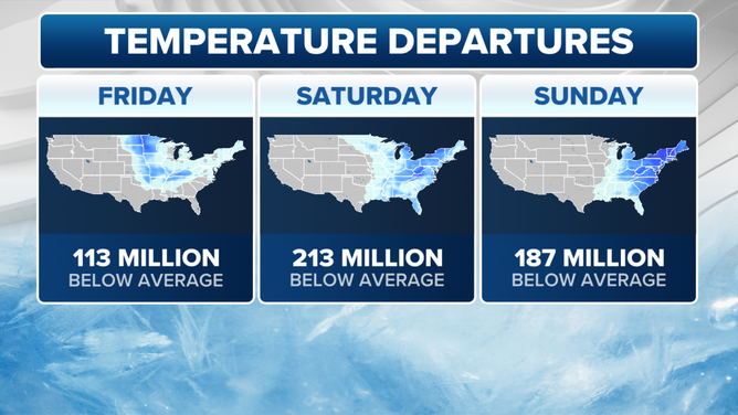
A look at temperature departures in the eastern U.S. through Sunday.
(FOX Weather)
Northerly winds begin to usher in the cold as soon as Friday night, with over 200 million Americans waking up to below-average temperatures for the start of the weekend.
Highs on Saturday are expected to reach into the 20s and 30s. However, by Sunday morning, low temperatures will drop into the teens and even single digits for interior portions of the Northeast.
When winds gusting up to 30 mph are factored in, it will feel more like the single digits or even subzero in areas such as Boston and Syracuse, New York.
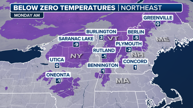
A look at below-zero temperatures in the Northeast on Monday morning.
(FOX Weather)
This cold continues into Monday, the start of the holiday week, too, with many waking up in the single digits. Monday morning could easily go down as the coldest start since February 2023.
Luckily, the chill is short-lived and the warmth engulfing most of the country moves into the Northeast by Thursday.
Thunderstorms expected across South
A developing storm system is expected to start tapping into moisture from the Gulf of Mexico on Monday, which could produce a few scattered showers and thunderstorms from Texas into southern Missouri.
Chances of rain will continue through at least Christmas Eve and by the time the precipitation amounts could total 2-3 inches in the Texarkana region.
A few of the thunderstorms could be strong to severe with gusty winds, cloud-to-ground lightning and heavy rainfall being the greatest threats.
Rainfall rates of over an inch an hour could lead to isolated pockets of flash flooding, but most of the rain will be welcome news as the region has been stuck in a drought for months.

(FOX Weather)
End-of-year warmup on the way
From frigid cold to oddly mild, the FOX Forecast Center is monitoring an end-of-year warmup that will impact hundreds of millions as we wrap up 2024.
Forecast models suggest that a fairly strong and intense Pacific jet stream could develop around Christmas out over the middle of the Pacific Ocean. This can have many implications for the weather in the U.S.
Typically, this results in not only a warmer-than-average airmass for the Lower 48, but it can also result in a more active storm track.
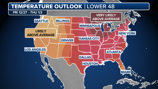
A look at the post-Christmas temperature outlook for the U.S..
(FOX Weather)
The Climate Prediction Center’s extended temperature and precipitation outlook highlights this well, showing all the Lower 48 above average for the week after Christmas, and almost everyone – except southern portions of the Southwest – above average for precipitation.
High temperatures are expected to soar 10-20 degrees above average, with potentially over 200 million feeling the warmth in early 2025.
https://images.foxweather.com/static.foxweather.com/www.foxweather.com/content/uploads/2024/12/1024/512/gettyimages-1245859196.jpg?ve=1&tl=1
2024-12-20 10:33:34


